Fun west swell to end the week

South Australian forecast by Craig Brokensha (issued Wednesday March 5th)
Best Days: Mid Coast later tomorrow and Friday, South Coast Saturday and Sunday mornings (smaller Sunday)
Features of the Forecast (tl;dr)
- Moderate sized W/SW swell building later tomorrow, holding Fri
- Strong S/SE-SE winds tomorrow, moderate E/SE-E tending S/SE Fri (possibly E/NE for a period down South in the AM)
- Small surf on the weekend with N/NE winds down South in the AM
- Moderate sized, inconsistent SW groundswell building later Mon with variable tending S winds, peaking Tue AM
- Fresh E/SE-SE tending strong S/SE winds Tue
Recap
The good run of W/SW swell eased back to a tiny 1-1.5ft through yesterday on the Mid Coast while the South Coast was the pick under offshore winds and with a fun, easing 2-3ft of swell.
Today both coasts are tiny with the South Coast seeing an early window of light winds ahead of an approaching trough and onshore change.
This week and weekend (Mar 6 - 9)
The South Coast will see a poor end to the week, while the Mid Coast is due to benefit from another healthy pulse of W/SW swell later tomorrow and Friday.

The source of this swell was a healthy, slow moving frontal progression that projected up towards Western Australia and then slipped south more towards us through the weekend and early this week.
A fun pulse of energy to 2ft is due later tomorrow, holding Friday on the favourable parts of the tide with the South Coast reaching 2-3ft at the swell’s peak, helped by an additional, mid-period SW swell.
Winds will favour the Mid Coast tomorrow and be strong from the SE-S/SE all day (terrible down South) with winds easing and tending E/SE on Friday across the Mid Coast, E-E/NE down South ahead of relatively weak sea breezes inside the gulf.
Saturday is still the pick for the South Coast with a N/NE offshore and smaller, easing 2ft waves across Middleton and tiny on the Mid Coast.
A long-period signal showing on Sunday hasn’t got any size to it, with it generated by a poorly structured low that’s currently west-southwest of Western Australia.
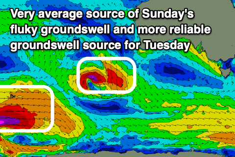
This will generate a possibly 1-2ft wave across Middleton and 1ft waves inside the gulf, with the models incorrectly combining swells and over-forecasting the size.
Local winds look favourable most of the day Sunday and-N/NE, with the exposed beaches being the pick ahead of a late SW change as a trough moves through.
Moving into Monday and early variable winds may be seen ahead of freshening S’ly winds as a stronger trough moves through, and we should see some inconsistent, SW groundswell building through the day.
This swell is being generated by a strong polar low that’s formed south-east of South Africa, with a great fetch of sever-gale to storm-force W’ly winds due to project east today, weakening a little while projecting slightly east-northeast tomorrow.
A moderate sized swell is due later Monday but more so Tuesday with 3-4ft waves off Middleton (1ft Mid Coast) but with poor E/SE-SE winds, easing Wednesday as winds slowly improve.