The fun run for the Mid Coast has begun
South Australian forecast by Craig Brokensha (issued Friday February 28th)
Best Days: Mid Coast today through Monday, South Coast tomorrow morning and for the keen Sunday morning, South Coast Tuesday morning
Features of the Forecast (tl;dr)
- Secondary pulse of slightly stronger W/SW swell for later today, and tomorrow AM
- Variable offshore winds tomorrow AM, ahead of sea breezes (gusty on the Mid Coast)
- Moderate sized W/SW-SW groundswell Sun with moderate S/SE winds, strengthening through the day
- Easing swell Mon with mod-fresh E/SE-E tending stronger S/SE winds
- Smaller mix of easing SW and S/SE swells Tue with NE tending SE winds
- Strengthening S-S/SE winds Wed
- Moderate sized, mid-period W/SW swell for later week with morning offshores for the Mid Coast
Recap
The Mid Coast offer tiny waves to 1ft+ yesterday morning before starting to build through the afternoon to a slightly wind affected 1-2ft as the first pulse of W/SW swell filled in. This has held around an inconsistent 1-2ft this morning (improving on the dropping tide) while the South Coast built through the afternoon and is now a good 3ft this morning. Light onshore winds are creating workable conditions for the keen.
Our next pulse of W/SW swell energy is due later this afternoon and this should provide more consistent 2ft sets, discussed in more detail below.

Improving conditions on the dropping tide today
This weekend and next week (Feb 29 - Mar 7)
One pulse down, two to come.
The current swell is the first in a series of swells due over the coming days, generated by a healthy, strengthening progression of storms firing up towards Western Australia and then moving under the country.
Later today and tomorrow morning, our secondary pulse of W/SW swell energy is due, with more consistent size expected across both regions thanks to the frontal progression linked to it being stronger in nature.
A good fetch of strong to near-gale-force W-W/NW winds passing under Western Australia yesterday generated the swell, with good 2ft waves due on the Mid Coast (possibly odd bigger one on the favourable parts of the tide), with 3ft to occasionally 4ft sets off Middleton, easing through the day. This easing trend only applies to the South Coast.
Local winds look favourable for both coasts and variable offshore during the morning tomorrow before relatively weak sea breezes kick in down South (fresher inside the gulf).
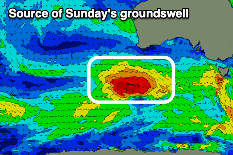
We then look at the third and final pulse of groundswell due into Sunday, with this coming in the strongest of all for the South Coast.
This is being generated by a strong though fast moving low moving in from the west with fetches of gale to nearly severe-gale W-W/NW winds due to produce a moderate sized pulse of swell that’s due to peak Sunday to 4-5ft off Middleton as the Mid Coast holds the 2ft range.

The Mid Coast will offer the best conditions Sunday in the wake of a trough Saturday evening, with moderate S/SE winds due, freshening through the day. The South Coast won’t be great but with the strength of the swell, doable for the keen.
Sunday’s swell will start fading into Monday with easing 1-2ft sets on the Mid Coast and 3-4ft waves off Middleton as winds improve and tend more E/SE-E through the morning. This isn’t ideal for the South Coast with Tuesday still the pick with a NE morning breeze and mix of easing SW swell and S/SE windswell from a peaky 2-3ft.
Wednesday is dicey with smaller levels of leftover swell and strengthening S/SE winds as a trough moves through.
Longer term we’re expected to see an incoming frontal progression from the South West of Western Australia weakening while moving towards us next week, bringing a moderate sized increase in W/SW swell for the Mid Coast Thursday afternoon and Friday. Winds look favourable but more on this Monday. Have a great weekend!


Comments
Latest notes are live.
Does anyone have a link to anyform of wave modelling for the Spencer gulf?
Something that could show the effects of differing angle and sizes would be amazing...even if it was a rough estimate.
Sensational summer for both coasts, and it’s still going to continue; Owe Danny Boy️️
Our magic little run continues, it's been one of the better summers we've had for a long while, warm weather and lots of little waves to muck around on! Yew!
100 per cent. January was great, early Feb sucked, but now we're on a run again. C'mon Autumn!
only if the bom could get the cape decoudic wave bouy functioning again, add it into the cash splash.
Yep, moving into March now..