Good Mid Coast run with dicey winds for the South Coast
South Australian forecast by Craig Brokensha (issued Wednesday February 26th)
Best Days: Mid Coast Friday morning, Saturday morning both coasts, Sunday Mid Coast, Monday Mid Coast, Tuesday morning South Coast
Features of the Forecast (tl;dr)
- Small start to tomorrow ahead of a late increase in moderate sized W/SW swell, peaking Fri AM
- Secondary pulse of slightly stronger W/SW swell for later Fri, peaking Sat AM
- Light E/NE-NE winds ahead of sea breezes tomorrow
- Developing S/SW winds Fri, likely variable at dawn and light S/SE-S on the Mid in the AM
- Variable winds Sat AM, E/SE on the Mid and E/NE-NE down South ahead of sea breezes
- Mod-large W/SW-SW groundswell Sun with S/SE tending S/SW winds on the Mid (back to the S/SE later) S all day down South
- Easing swell Mon with fresh SE tending stronger S/SE winds
- Smaller Tue with NE tending SE winds
Recap
Monday’s great pulse of W’ly swell eased back to a less consistent 1-2ft yesterday while today we’ve got glassy conditions but tiny, 1ft+ leftovers.
The South Coast was fairly lumpy and not ideal yesterday morning, though fun later morning while today is much cleaner but small and back to 1-2ft off Middleton.
This week and weekend (Feb 27 - Mar 2)
We’ve got three pulses of W/SW-SW swell due over the coming period, with each being better than the one before.
Tomorrow morning is expected to start small to tiny, but into the late afternoon, some new, mid-period W/SW swell is expected, with this holding Friday morning ahead of a stronger pulse Friday afternoon/Saturday morning.
The first swell for later tomorrow has and is still being generated by a healthy frontal system that projected towards Western Australia earlier this week but is now weaker and generating a healthy fetch of strong, expansive W’ly winds to the south of the country.
The Mid Coast could see 2ft sets later tomorrow but come in more reliable on Friday with Middleton offering 2-3ft waves later tomorrow, coming in at 3ft on Friday morning.

A secondary, stronger frontal system moving in from the south-west of Western Australia should produce a stronger pulse for later Friday but more so Saturday morning to a good 3ft+ across Middleton as the Mid Coast holds in the 2ft range on the favourable parts of the tide.
Coming back to the local winds and tomorrow should see light E/NE-NE winds across the South Coast, E/SE on the Mid before relatively weak sea breezes kick in.
Friday is a touch dicey with a trough due to move in around dawn. We may see a period of variable winds but this looks short-lived ahead of freshening S/SW-SW winds down South, SW on the Mid from about midday.
Saturday looks better with variable tending E/SE winds on the Mid Coast, likely E/NE-NE down South through the morning before sea breezes kick in.

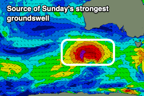
Our third and final pulse of stronger groundswell for Sunday is still on track with a strong low due to move in behind the first two systems, generating a great fetch of severe-gale W/NW winds on top of an already active sea state.
This should produce a moderate to large sized W/SW-SW groundswell for Sunday, coming in at at a stronger 2ft to possibly 3ft on the Mid Coast with 4-5ft+ waves off Middleton though with less favourable, S’ly winds that should be S/SE for a period through the morning on the Mid Coast ahead of sea breezes, back to the S/SE later.
Monday will be great on the Mid with the swell easing back from 2ft under fresh SE winds, only tending S/SE into the afternoon.
An improvement in local conditions is likely down South on Tuesday as the trough linked to Sunday’s change pushes east, allowing winds to swing around the NE but with small levels of easing swell. More on this Friday.


Comments
any locals got views on the activities surrounding the backhoe on the christie's surfcam..
anyone a regular diver at horseshoe reef..?
https://www.abc.net.au/news/2025-01-17/epa-christies-beach-seawall-witto...