Good run for the Mid Coast with windows down South

South Australian forecast by Craig Brokensha (issued Monday February 24th)
Best Days: Mid Coast today and tomorrow, South Coast tomorrow morning and more so early Wednesday, Mid Coast Friday through Monday, South Coast early next week
Features of the Forecast (tl;dr)
- Easing W/SW-SW swell tomorrow with E/NE-NE winds down South, E on the Mid ahead of relatively weak sea breezes
- Smaller Wed with early, light, local offshore winds ahead of a shallow SW change mid-late AM
- Late increase in W/SW swell Thu, peaking Fri with a secondary pulse for later Fri, peaking Sat AM
- Early variable winds Fri, tending S/SW through the day with S/SE-SE winds on Sat
- Slightly stronger W/SW-SW groundswell filling in Sun with SE tending S/SE winds
- Easing swell next week as winds tend E/NE-NE
Recap
Saturday was the pick down South with a fun swell to 2ft to occasionally 3ft across Middleton with favourable winds most of the day, tiny inside the gulf.
Yesterday was small to tiny but a mix of building windswell and new W/SW energy showed into the afternoon, with today revealing the peak. The Mid Coast has improved all day with inconsistent but great 2-3ft waves while the South Coast is chunky and winds doable with a moderate to fresh onshore breeze.

Good sets this morning
This week and weekend (Feb 25 - Mar 2)
Make the most of the peak in swell today on the Mid Coast.
The slow moving mid-latitude low linked to today’s swell has drifted away to the south-east, with high pressure due to move in behind it over the coming days.
This will allow winds to ease and shift E/NE-NE down South tomorrow along with easing levels of swell back from 3-4ft across Middleton with inconsistent 2ft waves across the Mid Coast.
Sea breezes look only relatively weak, kicking in early afternoon, with Wednesday coming in smaller down South and to 2ft, with tiny waves inside the gulf. Early, light, local offshore winds create clean conditions ahead of a shallow SW change mid-late morning.
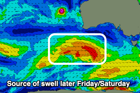
This change will be shallow and winds should revert back to the E/SE on Thursday morning down South, while swell wise, we should see some new, mid-period W/SW swell energy arriving later in the day, but more so Friday ahead of a better pulse later Friday and more so Saturday morning.
The source of the first swell will be a broadening but weak fetch of W/SW winds projecting up and then moving under the country over the coming days, while the secondary swell will be generated by a secondary slightly stronger but less favourably aligned frontal system moving under Western Australia on Wednesday.
The Mid Coast should see ebbs and pulses of swell either side of 2ft from Friday through Saturday, with the South Coast should come in around 2-3ft on Friday across Middleton with 3ft+ waves Saturday morning.

Local winds on Friday are a little tricky with a trough due move through during the morning bringing S/SW winds, though we may see variable offshore winds across both coasts with S/SE-SE winds on Saturday.
We then look at a third, stronger system moving in from the south-west of Western Australia mid-late week. A tight low is due to produce a fetch of sever-gale to possibly storm-force W’ly winds while tracking east, expanding while weakening under the country.
This should generate a mix of mid-period and stronger groundswell for Sunday, building to 4-5ft+ across Middleton while maintaining 2ft sets on the Mid Coast under morning SE winds.
Early next week should then improve down South as the swell eases. More on this Wednesday.