Get out today down South

South Australian forecast by Craig Brokensha (issued Monday February 3rd)
Best Days: Today, Mid Coast Thursday and Friday morning, Mid Coast Saturday for the keen
Features of the Forecast (tl;dr)
- Easing surf tomorrow with mod-fresh SW winds, strengthening from the S/SE
- Strong SE-S/SE winds Wed
- Moderate + sized mix of W/SW-SW swells building later Wed, peaking Thu with E/SE winds ahead of sea breezes (E/NE down South early)
- Easing surf Fri with strong S/SE winds
- Mod-large sized SW groundswell Sat wit strong SE-S/SE winds
- Easing swell Sun with strong SE-S/SE winds
Recap
The Mid Coast hovered either side of the 1ft range on the weekend, best Saturday and slower yesterday with less favourable winds.
The South Coast was fun and a bit lumpy on Saturday with 3ft sets off Middleton, cleaner yesterday morning but smaller with a drop in energy.
Today, our new pulse of S/SW groundswell has come in nicely with a boost back to 3ft off Middleton with a moderate to fresh offshore wind while the Mid Coast has come in much better than expected with 1-2ft sets now showing on the dropping tide.


Fun surf today
This week and weekend (Feb 4 - 9)
Today’s increase in size will be short-lived with the low linked to it only firing up late in our swell window and tracking slowly south-east.
A trough will bring a strengthening SW tending S’ly wind around dawn tomorrow down South, creating poor conditions while the Mid Coast should see variable tending stronger S/SE. Easing 1ft+ sets are expected inside the gulf with 2ft+ waves off Middleton.
Strong S/SE-SE winds will persist into Wednesday, easing and tending E/SE across the Mid Coast Thursday morning with an E/NE breeze likely down South.
This will be along with a mix of new W/SW groundswell and mid-period energy that’s due to build later Wednesday but peak Thursday across all locations.
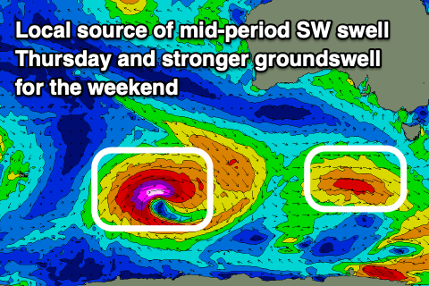
The source of these swells was a strong low that formed south of South Africa last week, slowly moving east towards the country while weakening on the weekend.
The remnants of this storm are now south of the country, still generating a healthy fetch of strong W/SW winds that will intensify slightly south-west of us tomorrow. This will add an additional SW component to the swell, with the mix of swells due to come in at 4ft across Middleton with 2ft sets on the Mid Coast, easing Friday from 3ft and 1ft to possibly 2ft respectively.
Unfortunately winds will revert back to the S/SE on Friday, strengthening through the day, favouring the Mid Coast while writing off the South Coast.
Into the weekend, a lingering trough in our region will bring with it strong SE-S/SE winds that will spoil a good, moderate to large pulse of SW groundswell Saturday.
This will be generated by a strong polar low firing up to the south-west of Western Australia this evening and tomorrow. The low will actually intensify as the remnants of Tropical Cyclone Elvis which was off Madagascar was absorbed into the westerly storm track.
A great fetch of severe-gale to storm-force W/SW winds should produce a moderate to large SW groundswell for Saturday to 5-6ft across Middleton with the Mid likely to come in around 1.5ft, though the favourable parts of the tide might boost this a little.
Longer term the outlook is more wishy washy, check back Wednesday.