Average run of for the South Coast

South Australian Forecast by Craig Brokensha (issued Friday January 10th)
Best Days: Mid Coast for the keen Sunday, South Coast for the keen Sunday and Monday mornings, protected spots South Coast Wednesday afternoon, Friday Mid Coast for the keen
Features of the Forecast (tl;dr)
- Moderate sized W/SW groundswell arriving later tomorrow, peaking Sun, easing Mon
- S/SE-SE tending stronger SW-S/SW winds later tomorrow on the Mid
- S/SE-SE tending S/SW then S/SE winds on the Mid Sun, light to moderate S down South, freshening
- Easing swell Mon with S/SE-SE tending S/SW winds on the Mid, W/SW-SW tending S down South (possibly W/NW early)
- Smaller Tue with similar winds
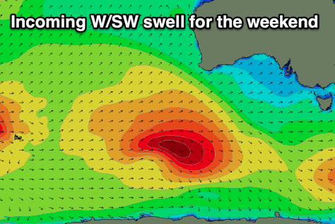
- Mix of stormy W/SW swell building Wed and long-range groundswell with strong W/SW winds
- Larger SW swell down South Thu with strong W/SW tending S/SW winds
- Easing surf Fri with strong S-S/SE winds
Recap
The Mid Coast bottomed out the last two days while the South Coast offered small to tiny, lumpy waves yesterday morning, small and onshore today.
This weekend and next week (Jan 11 - 17)
Tiny surf is due tomorrow and a morning SW breeze will create bumpy conditions down South, with only a slim chance of light W/NW winds locally. The Mid should be clean but near flat, while freshening sea breezes will add bumps to a building W/SW groundswell.
There’s been no change to the expected size across the regions with the Mid Coast due to build to 1.5ft later tomorrow but with strong SW-S/SW breezes, holding a similar size Sunday (possibly rare bigger one with the tide).
Middleton should come in at 3ft+ on Sunday and winds will linger out of the S/SW across the South Coast, though only light to moderate in strength creating workable conditions. The Mid Coast should see early S/SE-SE winds ahead of sea breezes, shifting back S/SE on dark.
The easing trend will be slow through Monday but the Mid Coast will be tiny and cleanest under a morning S/SE-SE wind. The South Coast looks likely bumpy again with a weak W/SW-SW breeze, with a possibility of light W/NW winds at dawn around Victor. Easing surf from 2-3ft is due across Middleton, smaller Tuesday as winds play out similar to Monday.
Now, into Wednesday a deep low moving in from the west will bring strong W/NW winds along with a stormy increase in windswell across the Mid Coast to 3-4ft through the day, easing through Thursday as winds abate and shift more S-S/SW.
The South Coast won’t see much in the way of windswell thanks to the blocking effects of Kangaroo Island on Wednesday, but a great fetch of gale-force projecting towards us into the evening looks to generate a large increase in size through Thursday.

Quickly coming back to Wednesday though, and an inconsistent, strong W/SW groundswell generated in our far swell window should be visible across the South Coast, with a slow increase in size to 3ft due across Middleton.
Thursday’s large swell looks to come in at 6ft or so but with those strong W/SW tending S/SW winds, smaller Friday under strong S-S/SE winds. The Mid Coast looks workable and to 1-2ft on Friday.
Longer term, the remnants of the low moving through Wednesday/Thursday looks to reintensify off the Gippsland Coast Friday/Saturday, bringing with it a poor run of S’ly winds for the South Coast with cleaner conditions inside the gulf and some long-range W/SW swell. We’ll have a closer look at this on Monday though. Have a great weekend!