Average summer outlook

South Australian Forecast by Craig Brokensha (issued Monday January 6th)
Best Days: No good days (Mid Coast for the desperate Sunday morning)
Features of the Forecast (tl;dr)
- Weak S/SE windswell across the South Coast over the coming days, bottoming out late week
- Gusty E/SE tending S/SE winds tomorrow, light N/NE tending fresh S/SE Wed
- Variable tending S/SE winds Thu, fresh S Fri (possibly light early)
- Small-moderate sized W/SW groundswell building later Sat, peaking Sun AM
- Light SE tending fresh SW winds on the Mid Coast Sat, SW and freshening down South
- Gusty S/SE winds Sun
Recap
The South Coast was the pick of the weekend with clean morning conditions that remained favourable into the afternoon Saturday under variable breezes. A new SW groundswell provided a fun boost in energy to 3ft off Middleton during the morning before easing into the afternoon and further yesterday with freshening onshore winds.
The Mid Coast was tiny Saturday with the early high tide claiming the fading energy from late week, even smaller yesterday.
Today we’ve got terrible conditions with a local windswell on the South Coast and tiny 1-1.5ft waves inside the gulf but they’re lacking punch.

Good surf Saturday
This week and weekend (Jan 7 - 12)
After a great run of early summer swell, we’re set to enter the typical doldrums thus week, with a new pulse of small W/SW groundswell due on the weekend.
Today’s poor winds on the South Coast are associated with a trough moving through, but this will quickly be followed by high pressure allowing winds to shift E/SE tomorrow morning but remain at strength.
This will create generally poor conditions along with a localised S/SE windswell.
Wednesday looks cleaner under a light, N/NE offshore but with a weak 1-2ft of easing S/SE windswell across Middleton. If you must surf try the magnets.
The Mid Coast will become tiny to flat tomorrow and be unsurfable for the rest of the week.
The surf will also bottom out across the South Coast into the end of the week though with variable morning winds Thursday ahead of another trough and fresh S/SE breezes into the afternoon, persisting out of the S’th on Friday.
Saturday morning will start tiny again, while a new long-range W/SW swell is due into the afternoon, likely peaking Sunday morning.
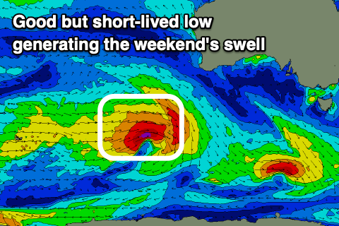
The source will be a healthy low firing up to the south-west of Western Australia mid-week, with a short-lived fetch of gale to severe-gale W/SW winds due to generate a small to moderate sized pulse of swell that should come in at 1-1.5ft across the Mid Coast late Saturday and Sunday with the South Coast seeing 3ft+ sets on Sunday.
Winds will be sea breezy across all locations Saturday afternoon when it starts to build, with Sunday seeing strong S-S/SE winds, writing off the South Coast.
Longer term S/SE winds look to persist early next week ahead of a shift to the W/SW-SW mid-week as a cold front pushes through. Any swell looks to be spoilt by onshore winds on the South Coast with tiny waves inside the gulf. More on this Wednesday.