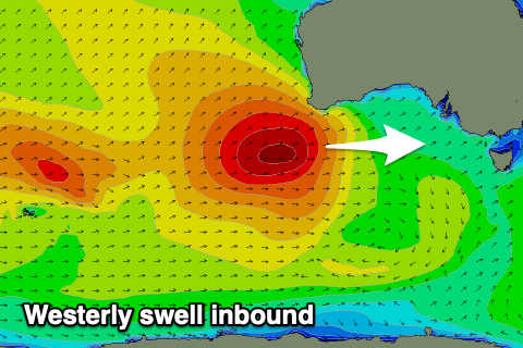
Great west swell inbound
South Australian Forecast by Craig Brokensha (issued Monday December 16th)
Best Days: Mid Coast late tomorrow, Wednesday and Thursday morning, South Coast Thursday morning and dawn Friday
Features of the Forecast (tl;dr)
- Large W/SW groundswell building tomorrow PM, holding Wed AM, then slowly easing
- Strong SW winds tomorrow, easing slowly into the PM (tending S-S/SE on dark)
- Gusty SE tending stronger S/SE winds Wed
- Easing swell Thu with NE tending S/SE winds down South E tending W winds on the Mid
- Small, inconsistent W/SW groundswell Fri with early variable tending strong SW winds
- Poor weekend with strong S-S/SE winds Sat, fresh S-S/SW winds Sun
Recap
Conditions were peaky and fun on Saturday morning with plenty of swell hanging in at 2-3ft across Middleton, while yesterday the size dropped back to 1-2ft. This morning was holding in at 1-2ft with strengthening offshore winds ahead of a strong, cool change.
The Mid Coast has been tiny with the swell bottoming out today.
This week and weekend (Dec 17 - 22)
The coming week revolves around a large westerly swell due into tomorrow afternoon and Wednesday across the state, with today’s change linked to the frontal progression bringing the swell.
The swell will be very west in nature, generated by a great, slow moving low that formed to the south-west of Western Australia over the weekend.
Fetches of mostly gales, with slightly stronger embedded core winds have generated a large swell for Western Australia today that will lose a touch of size while moving through the Bight but come in strong across the Mid Coast with a little less size down South.
We should see strong SW winds persisting across both coasts tomorrow morning, with the swell building to the 3ft range across the Mid Coast later in the day with 4ft sets across Middleton. Right on dark winds should tend more S-S/SE opening up a window for the savvy.

Wednesday is the pick as winds shift back to the SE cleaning up the Mid Coast as the swell holds 3ft (though not ideal with the big morning high tide). The South Coast will be a mess with 4-5ft sets across Middleton, easing through the day.
Into Thursday the swell will start to ease and conditions should improve down South with a light NE offshore and easing, peaky sets from 3ft with 2ft waves inside the gulf.
Friday will see early variable winds but you’ll have to be quick as a strong change will be in by mid-morning and the swell will be at a low point in any case down South, while the Mid Coast should see 1-1.5ft sets persisting as a long-range, background W/SW groundswell fills in.
Come the weekend, strong S-S/SE winds will create poor conditions Saturday as the Mid Coast starts easing back from 1-1.5ft, with fresh S-S/SW winds due to linger into Sunday.
This will be thanks to the trough bringing Friday’s change turning into a low off the East Coast, directing those poor winds into our state.
Into next week we’ll see onshore winds on Monday, tend variable and offshore Tuesday/Wednesday with what looks to be a moderate sized SW groundswell. More on this Wednesday.

