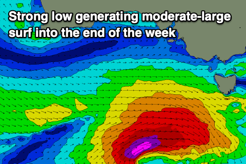
Upgrade in swell to end the week but with dicey winds
South Australian Forecast by Craig Brokensha (issued Wednesday December 11th)
Best Days: South Coast tomorrow morning, Mid Coast for the keen Friday morning, South Coast Saturday morning, Mid Coast next week
Features of the Forecast (tl;dr)
- Moderate + sized S/SW groundswell arriving later tomorrow, peaking overnight, easing Fri
- Variable tending locally offshore winds tomorrow AM, tending S/SW and freshening into the PM
- Moderate S winds down South Fri AM, freshening with S/SE winds in the AM on the Mid
- Easing swell on the weekend with morning E/NE-NE winds ahead of sea breezes down South
- Building W/SW swell Tue with S/SW winds, stronger into Wednesday/Thursday with local offshore winds on the Mid Coast, unknown down South
Recap
The swell faded back in size yesterday from 1-1.5ft across the Mid Coast with weaker, peakier options this morning.
Middleton was 3ft and workable with a moderate to fresh S’ly breeze, smaller today with a messier conditions.
This week and weekend (Dec 12 - 15)
The coming period is active with decent swell producing storms moving through our swell window thanks to a negative Southern Annular Mode event, lifting the westerly storm track further north than normal.

Keeping this in mind, the strong pulse of S/SW groundswell for later tomorrow and Friday is on track, with a deepening low currently forming south-west of us being upgraded in strength.
With this, fetches of gale to severe-gales are currently moving through our southern swell window, generating a moderate sized pulse of S/SW swell that should build through tomorrow afternoon, reaching 4ft later but likely peaking overnight to more size, easing steadily from 4ft on Friday morning.
The Mid Coast only looks to reach 1-1.5ft at the peak of the swell and will be mostly a tease.
Conditions are now looking better for the South Coast tomorrow morning and also clean inside the gulf through the morning (ahead of the swell) with variable tending light offshore breezes ahead of freshening sea breezes, only light initially.
On Friday, a moderate S/SW breeze will create less than ideal conditions down South, but with the strength of the swell, it should still be OK, while the Mid Coast should see morning S/SE breezes.
The swell will ease back through Saturday from 2-3ft across Middleton, smaller Sunday while the Mid Coast will become tiny. An E/NE-NE breeze will create decent conditions down South both mornings, but Saturday looks to be the pick.

Into next week, we’ve got tiny small to tiny levels of swell ahead of a moderate + sized run of W/SW swell from Tuesday but more so Wednesday/Thursday.
This will be generated by a strong, mid-latitude frontal system projecting up towards and then under Western Australia over the weekend, moving further under the country and towards us early next week.
Winds initially look onshore out of the S’th Tuesday and then more offshore Wednesday but we’ll confirm this on Friday.

