Good end to the week
South Australian Forecast by Craig Brokensha (issued Wednesday December 4th)
Best Days: Today, tomorrow (morning South Coast)
Features of the Forecast (tl;dr)
- Slight drop in W/SW swell tomorrow with local offshore winds and weak sea breezes (late afternoon South Coast), variable later on the Mid
- Easing swell Fri with variable winds, sometimes offshore, sometimes onshore
- Moderate sized W/SW swell Sat with dawn variable tending fresh S/SW-SW winds
- Easing swell Sun with fresh S/SW winds, likely S/SE early on the Mid
- Small-mod sized mid-period SW swell Mon with E/SE winds on the gulf ahead of sea breezes, E/NE down South
- Easing surf Tue with S/SE-SE winds
Recap
Yesterday was generally poor across both coasts with early OK conditions down South but a drop in swell from Monday afternoon, which kicked to 2-3ft. The Mid Coast was tiny and windswelly while some new swell due later failed to really show with any conviction.
This morning, a large high tide in the gulf swallowed up our W/SW swell energy, with it looking very slow and to 1-2ft max. The dropping tide has revealed the expected size though with 2-3ft sets under variable winds that have now gone sea breezy.
The South Coast is also clean and fun but best now ahead of sea breezes.

There's the swell!
This week and weekend (Dec 5 - 8)
Today’s W/SW energy will be followed up by a secondary pulse of lesser period W/SW energy tomorrow morning and this should maintain 2ft sets across the Mid Coast, but that early high tide won’t be ideal again.
The South Coast should be 2-3ft off Middleton before easing through the day.
Local winds look light offshore, shifting N/NW-NW inside the gulf and variable later with late afternoon sea breezes down South.
Friday looks smaller but not below 1-2ft on the Mid Coast owing to reinforcing levels of W’ly energy filling in, generated on the back side of the low linked to today’s energy.

The South Coast looks smaller and to 1-2ft and variable winds will make for slightly funky conditions before going sea breezy.
Into Saturday the trough linked to Friday’s funky winds will move through proper with dawn variable breezes due to freshen from the SW-S/SW.
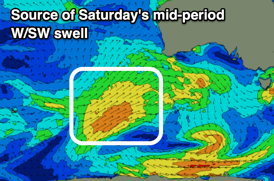
This will spoil a good reinforcing pulse of mid-period W/SW swell, generated by a healthy frontal system that’s currently south-west of Western Australia. This will project a good fetch of strong W/SW winds towards us, with a small to moderate sized mid-period swell due to boost back to a consistent 2ft, easing from 1-2ft on Sunday. The South Coast should see 3ft waves on Saturday, easing into Sunday.
The easing trend will be slowed by further weak frontal activity moving under Western Australia Friday and then below the Bight Saturday, with the Mid likely to continue to 1-1.5ft on Monday before easing Tuesday. The South Coast should perk back up to 2-3ft Monday before easing Tuesday.
Unfortunately winds on Sunday will remain generally average and gusty out of the S/SW, with a period of early S/SE breezes likely on the Mid, with Monday coming in with better E/SE offshores across the Mid Coast, E/NE down South.
Make the most of this window down South as winds look to revert back to the S/SE-SE through Tuesday-Thursday. More on this Friday.

