Fun tomorrow, tricky thereafter
South Australian Forecast by Craig Brokensha (issued Monday November 25th)
Best Days: Tomorrow South Coast, tomorrow afternoon Mid Coast, early Wednesday South Coast, possibly Saturday morning South Coast
Features of the Forecast (tl;dr)
- Small-mod W/SW swell building tomorrow with N/NE tending variable winds down South, E/NE tending N/NE then variable NW on the Mid
- Easing swell Wed with strengthening N/NW-NW tending W/NW winds ahead of a late W/SW change
- Localised windswell on the Mid Coast Wed
- Easing surf Thu with S/SW winds
- Moderate sized SW groundswell building Fri, peaking in the PM with moderate S winds down South, S/SE-SE in the AM on the Mid
- Easing swell Sat with variable S winds, increasing
Recap
A trough brought an onshore change do the South Coast just before dawn on Saturday but winds tended variable thereafter, creating workable waves for the keen. The swell was much smaller though and best on the magnets.
Yesterday was poor with no real swell left in the tank under onshore breezes.
The Mid failed to offer any real surfable waves of substance.
Today is small and onshore again down South with tiny waves inside the gulf.
This week and weekend (Nov 26 - Dec 1)
Looking at tomorrow and we’ve got our good pulse of W/SW swell due to fill in through the day, generated by a healthy front moving in from the South West of WA, under the country on the weekend.
There’s no change to the expected peak in size with building sets to 1.5ft due on the Mid Coast with 2-3ft waves off Middleton into the afternoon, fading Wednesday.
Winds look favourable for both coasts tomorrow but best into the afternoon on the Mid with E/NE tending NE then variable NW winds while the South Coast looks great all day with a N/NE tending variable breeze.
Into Wednesday an approaching low looks to bring strong N/NW-NW tending W/NW winds ahead of a late W/SW change, kicking up some local windswell inside the gulf and favouring the South Coast early.

Unfortunately lingering S/SW winds are due into Thursday with fading surf, improving across the Mid Coast Friday and tending S/SE-SE while lingering onshore down South.
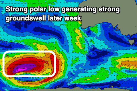
This will be along with the arrival and building of a strong new SW groundswell, generated by a polar low currently around the Heard Island region. This low is generating storm-force winds while projecting east and should kick up moderate levels of surf into Friday afternoon.
The South Coast is on track to reach 4-5ft into the afternoon across Middleton with tiny 1-1.5ft sets inside the gulf but with sea breezes, easing Saturday under what could be lingering S winds down South, though possibly variable. We’ll look at this closer on Wednesday.
Longer term a smaller, long range swell is due Monday week with winds unknown, more on this in the next update.

