Tricky outlook for the South Coast, small inside the gulf
South Australian Forecast by Craig Brokensha (issued Wednesday October 23rd)
Best Days: Mid Coast tomorrow morning and Friday, South Coast Friday morning, South Coast magnets Saturday morning, Mid Coast for the keen Monday
Features of the Forecast (tl;dr)
- Moderate sized W/SW swell tomorrow with fresh S/SW-SW winds, with a less consistent but fun reinforcing swell Fri with E tending SW winds (variable down South in the AM)
- Easing swell Sat with fresh N/NE tending weaker N/NW winds
- Small-mod sized W/SW swell Sun/Mon with fresh S/SW-SW winds Sun, S/SE on Mon
- Moderate sized SW swell building Mon, holding Tue with E/SE tending S/SE winds
- Moderate sized SW groundswell Wed with E/NE tending S/SE winds
Recap
Yesterday was a lay day across both coasts with onshore winds down South and varying winds but tiny surf across the Mid Coast.
Today we’ve got some new swell across both regions with cleaner conditions. The South Coast is 2-3ft across Middleton with 1-1.5ft sets inside the gulf.
This week and weekend (Oct 24 - 27)
Looking at the end of the week, and we’ve got some good W/SW swell on the way for tomorrow and Friday, but winds look to be average for the South Coast on the former as the remnants of the swell generating front linked to Friday’s swell moves through.
This will bring fresh S/SW-SW winds, better on the Mid and S/SE-SE early along with some good mid-period W/SW swell to 2ft+ generated by the earlier stages of the frontal system projecting up and under Western Australia.
Friday looks cleaner (for the Mid Coast) as winds ease and tend light E/SE along with some longer-range W/SW energy, maintaining 2ft sets while the South Coast looks to only come in at a similar 2ft.
There’s a good chance for variable winds down South as well Friday morning but it’ll likely still be quite lumpy following overnight onshore winds.
Winds are still expected to improve for the South Coast on Saturday, tending fresh N/NE and then weaker N/NW into the afternoon but swell wise, we’ll be looking at fading 1-2ft sets max, with tiny, wind affected waves on the Mid Coast.

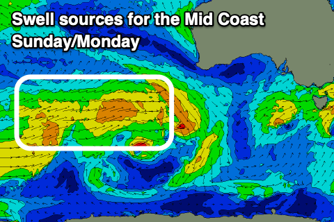
Come Sunday, another swell generating front clipping the state will bring unfavourable S/SW-SW winds, but with some new levels of mid-period W/SW swell are due to fill in, generated by a stream of not overly strong but healthy frontal activity projecting towards Western Australia over the coming days.
The swell should come in at a fun 1-1.5ft, with the South Coast only seeing 2ft surf and those average winds.
Cleaner conditions are due Monday as winds shift S/SE and a reinforcing pulse should maintain 1-1.5ft waves for the keen inside the gulf.
The South Coast is due to see some moderate sized mid-period SW swell building, generated by the progression over the coming days pushing further east, under the country on the weekend and early next week, but local winds don’t look to play ball at all, remaining fresh from the S/SE.

On Wednesday some new SW groundswell is due to fill in, generated by a strong but south-east tracking low following the front moving through Sunday/Monday, though it won’t offer much size inside the gulf, which will be cleanest.
The South Coast may see winds tend E/NE during the morning but we'll review this on Friday.
So all in all it looks like a bit of an average outlook for the South Coast with fun peelers inside the gulf.

