Good westerly energy to end the week
South Australian Forecast by Craig Brokensha (issued Wednesday October 9th)
Best Days: Later tomorrow Mid Coast but more so Friday and Saturday, South Coast Sunday (Mid Coast for the keen), South Coast Monday and Tuesday
Features of the Forecast (tl;dr)
- Building W/SW energy tomorrow with strong S/SW tending S-S/SE winds
- Moderate + sized W/SW groundswell for Fri, with a secondary SW pulse for the PM and Sat, easing Sun
- SE tending temporary S/SW winds Fri inside the gulf, mod-fresh S down South
- Fresh E/SE morning winds Sat inside the gulf, E/NE tending SE down South
- Variable winds on the Mid Sun, NW-W/NW down South
- Smaller Mon with variable winds
- Moderate sized S/SW groundswell Tue AM, easing with variable winds
- Moderate sized, inconsistent W/SW groundswell building Wed PM, easing Thu with winds unsure
Recap
The Mid Coast offered the best waves yesterday with the W/SW energy easing from 1-2ft under all day offshore winds, while this morning we’re back to a fading 1-1.5ft.
The South Coast was quite lumpy/bumpy with cross-shore easterly winds yesterday morning though plenty of swell still to 3-4ft, back to 2-3ft this morning with similar but improving conditions. Winds will hold out of E/NE this afternoon as the swell continues to ease.
This week and next (Oct 10 - 18)
Tomorrow will likely be a lay day as an approaching front clips us bringing strong S/SW winds that will shift S/SE-S across the Mid Coast.
We should see building levels of close-range W’ly swell from this frontal system, reaching 1-2ft later in the day across the Mid Coast with some building S’ly windswell down South.
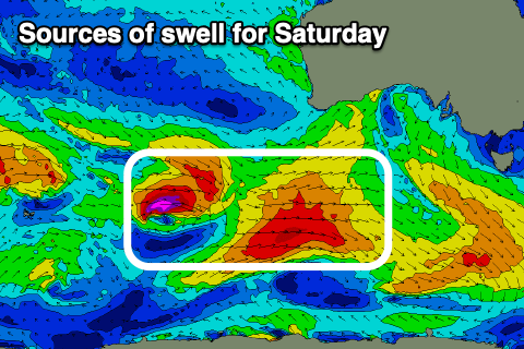
Of greater importance is the W/SW groundswell energy due into Friday and reinforcing SW swells for Saturday.
Friday’s swell was generated by the earlier stages of the frontal progression which formed in the southern Indian Ocean, projecting W’ly gales through the Mid Coast’s swell window, while Saturday’s energy is still being generated by secondary, more favourably aligned fetches of strong to gale-force W/SW winds to the south of Western Australia last night and today.

In addition to this, a secondary strong but tight front moving in behind the system currently south of Western Australia will generate further energy into Saturday mostly for the South Coast.
Coming back to the sizes, the first swell on Friday should come in at 2ft to possibly 3ft across the Mid Coast on the favourable parts of the tide with Middleton building to 4-5ft into the afternoon, with Saturday seeing 2ft and 4-5ft waves respectively inside the gulf and down South.
Local winds on Friday will be great for the Mid Coast and SE through the morning ahead of temporary S/SW sea breezes, (moderate to fresh S down South), with Saturday seeing fresh, E/SE morning winds across the Mid Coast, E/NE down South.
Sunday looks the best down South with a W/NW-NW offshore as the swell eases back from 3-4ft while the Mid Coast looks to see variable winds most of the day as a trough lingers in the region.
Moving into next week and the winds on Monday/Tuesday are a little tricky thanks to troughiness continuing in the region bringing mostly variable winds.
Swell wise, Monday looks smaller but a good S/SW groundswell is on the cards for Tuesday, generated by a low forming south-west of Tasmania on Sunday.
Beyond this, a very long-period W/SW groundswell from the Indian Ocean is due Wednesday afternoon with a possible S/SW change. We’ll have a closer look at this on Friday as the models diverge a little with the troughiness in the region.


Comments
any word on repair to CDC buoy?
Unfortunately not. Funding cuts across the BOM..