Healthy outlook which favours the Mid Coast
South Australian Forecast by Craig Brokensha (issued Monday October 7th)
Best Days: This morning both coasts, tomorrow morning Mid Coast, South Coast Wednesday morning, Mid Coast Friday and Saturday, South Coast Sunday morning
Features of the Forecast (tl;dr)
- Slowly easing W/SW swell tomorrow with SE tending E/SE then fresher S/SE-SE winds on the Mid. S/SE tending E/NE then S/SE winds down South
- Smaller, fading surf Wed with N/NE-NE winds
- Strong S/SW winds Thu AM, easing and tending S/SE
- Moderate + sized, inconsistent W/SW groundswell for Fri, with a reinforcing SW groundswell for the PM and Sat AM
- S/SW winds down South Fri, E/SE on the Mid in the AM
- Fresh E/SE winds Sat AM inside the gulf, E/NE down South
- Easing surf Sun with N/NW tending SW winds
Recap
Average conditions but plenty of swell for the Mid Coast on the weekend, with the South Coast coming in tiny Saturday and then small but building yesterday under strengthening W/NW winds.
Today we’ve got much better surf with lighter winds and good 3-4ft sets across Middleton, still lumpy in the gulf but a fun 2ft or so as our W/SW swell pulses mature. A trough will bring an onshore change later morning so surf soon.

Good surf this morning across the South Coast
This week and weekend (Oct 8 - 13)
The current run of W/SW swell energy is thanks to a progression of not overly significant but persistent frontal systems through our western swell windows over the past few days.
The activity is now weakening/clearing and with this we’ll see the energy starting to ease tomorrow as winds improve further for the Mid Coast.
We should still see 3ft+ waves across Middleton tomorrow morning with easing 2ft sets across the Mid Coast as high pressure brings SE tending E/SE winds ahead of possible temporary sea breezes, freshening from the S/SE-SE mid-late afternoon. The South Coast looks dicey with overnight S/SE winds only due to ease temporarily and tip E/NE creating lumpy/raw conditions.
Wednesday looks cleaner down South as winds tip N/NE-NE (holding all day) but with small fading 2ft sets across Middleton, tiny inside the gulf.
An approaching front will bring a strong S/SW change for dawn Thursday, easing and tending S/SE through the day.

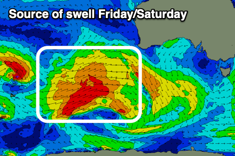
This change will be associated with the remnants of a strong frontal system moving in from the southern Indian Ocean, with it kicking up some low quality windswell later in the day and more so Friday, while stronger levels of W/SW-SW groundswell fill in underneath.
The groundswell component will be generated by gale-force fetches moving through our distant western swell window and then slightly better aligned activity to the south-west of Western Australia today and tomorrow.
The distant looks best for the Mid Coast, peaking through Friday (2ft to possibly 3ft on the favourable parts of the tide), with the better swell from under Western Australia due into Friday afternoon, building to 4-5ft across Middleton and then holding a similar size Saturday morning before easing.
The Mid Coast should see easing 2ft sets on Saturday as the swell direction dips a little more south of west.
Looking at the local winds and lingering S/SW winds will create average, bumpy conditions on the South Coast Friday with morning E/SE offshore winds across the Mid Coast ahead of weak sea breezes, while Saturday should see fresher E/SE winds across the Mid and E/NE winds down South. This won’t be ideal with the size of the swell down South.
Sunday looks the pick for the South Coast with easing 3-4ft sets and with a light offshore wind before another SW change moves through during the morning.
Into next week, the outlook is a little unknown wind and swell wise so check back here on Wednesday for a clearer idea.

