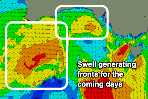
Plenty of west swell but with wind for the weekend
South Australian Forecast by Craig Brokensha (issued Friday October 4th)
Best Days: Protected spots Sunday afternoon South Coast, early Monday both regions, later in the day Monday Mid Coast, Tuesday Mid Coast, Wednesday morning South Coast
Features of the Forecast (tl;dr)
- Moderate sized W'ly swell tomorrow, followed by a secondary stronger W/SW swell for Sun/Mon
- Third slightly smaller mid-period W'ly swell Tue AM, easing
- Strong W/NW-NW tending W/NW winds tomorrow
- Mod-fresh W/SW tending W/NW winds Sun (W/NW all day down South)
- NW tending S/SW winds Mon (N/NE early on the Mid and S/SE later)
- E/SE tending S/SE winds on Tue
- Small Wed with E/NE-NE tending SE winds
- Moderate sized W/SW-SW swell Fri with winds unknown
Recap
The Mid Coast’s fun run of W/SW swell energy dried up yesterday as conditions deteriorated under strengthening northerly winds. Today is tiny with a building NW windswell now developing inside the gulf.
The South Coast was 2-3ft at dawn but quickly dropped back to 1-2ft across Middleton, tiny today.
This weekend and next week (Oct 4 - 11)
The frontal system that's moving through today has generated a good pulse of W’ly swell for tomorrow to 2ft+ across the Mid Coast, but winds will be strong from the NW-W/NW tending W/NW through the day, creating poor, choppy conditions. The South Coast will be cleaner but tiny owing to the west direction.

Some better mid-period W/SW swell energy is then due into Sunday, generated today by a healthy frontal system passing under Western Australia, with a fetch of strong W/SW winds due to maintain 2ft+ waves across the Mid Coast with the South Coast due to build towards 3-4ft into the afternoon.
Secondary frontal activity moving in tomorrow and then Sunday should produce reinforcing levels of W/SW swell energy for Monday and Tuesday morning respectively. The Mid Coast looks to persist to 2ft+ on Monday, easing from 2ft Tuesday with Middleton maintaining 3ft+ surf before easing into Tuesday afternoon.
Local winds on Sunday will shift from W/SW to W/NW across the Mid Coast through the day with the South Coast seeing persistent W/NW winds that will keep protected locations clean all day.
Monday is due to see a NW tending S/SW change and with this we may see early light N/NE winds across the Mid Coast at dawn, though quickly deteriorating during the morning. A late swing back to S/SE winds is then due, cleaning up the surf for the late session.
Winds will swing better E/SE on Tuesday morning as the W/SW swell energy starts to ease, while Wednesday looks cleanest down South as winds continue to shift around to the E/NE-NE during the morning.
Longer term, a good sized W/SW-SW groundswell is due into late Thursday but more so Friday next week, generated by a healthy frontal progression firing up to the south-west of Western Australia early next week.
Initial energy looks to be west in nature followed by a south-west component with winds uncertain thanks to model dovergence. We’ll have to look at this in more detail on Monday when the models should be more in alignment. Have a great weekend!

