Fun couple of days ahead
South Australian Forecast by Craig Brokensha (issued Monday September 30th)
Best Days: This afternoon Mid Coast, tomorrow morning Mid Coast, Wednesday both coasts, Thursday South Coast, Monday and Tuesday both coasts
Features of the Forecast (tl;dr)
- Moderate sized W/SW swell tomorrow, with a stronger SW pulse Wed easing steadily Thu
- Variable offshore winds across the Mid Coast tomorrow AM, W/NW-NW down South ahead of mod-fresh sea breezes
- E/SE-E/NE tending weak sea breeze winds Wed on the Mid, E/NE-NE tending SE down South
- Fresh to strong NE winds Thu, easing and tending N/NE into the PM
- Tiny Fri AM with freshening N/NW tending NW then W/NW winds
- Moderate sized W/SW swell Sat with fresh to strong NW tending W/NW winds
- Moderate sized W/SW-SW swell building Sun PM, peaking Mon, easing Tue
- Weaker W/NW winds Sun/Mon
- Early variable winds Tue AM inside the gulf, W/NW-NW down South
Recap
Fun surf across the exposed beaches on Saturday but way down on Friday morning’s size, best across the magnets before bottoming out into yesterday.
The Mid Coast was tiny on Saturday with a bumpy increase in W/SW swell yesterday which is a bit stronger and to 2ft+ today but with less than ideal conditions. We should see winds ease into the afternoon providing clean conditions for the keen while the South Coast has small clean conditions for the keen.
This week and weekend (Oct 1 - 6)
The week ahead will be mixed but fun across both regions, with the Mid Coast performing best first on Wednesday, followed by the South Coast on Thursday.

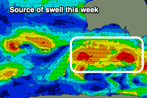
This will be thanks to a drawn out frontal progression currently south of the country, with it due to generate a fun, moderate sized mid-period W/SW tending SW swell.
We’re seeing multiple fetches of strong to at times gale-force winds generated through our south-western and southern swell windows, with building levels of mid-period energy due tomorrow, ahead of a peak through Wednesday while shifting a touch more south in direction.
The initial stages of the progression were best for the Mid Coast, with tomorrow expected to persist in the 2ft range, similar Wednesday before fading from 1-1.5ft on Thursday.
The South Coast looks to be more around 2-3ft across Middleton most of tomorrow, building late with Wednesday coming in around 4ft on the sets.
Local winds tomorrow will be variable offshore across the Mid Coast with W/NW-NW winds down South, giving into moderate to fresh sea breezes, with Wednesday seeing great E/SE-E/NE tending weak sea breezy winds on the Mid Coast, E/NE-NE tending SE down South.
Thursday will be the pick down South with a steadily easing swell from 3ft at dawn with fresh to strong NE winds, easing and tending N/NE into the mid-late afternoon but by then it’ll be back to 1-2ft.
Friday looks tiny ahead with a freshening N/NW tending NW and then W/NW wind along with some building mid-period W/SW swell late but more so for Saturday.
This swell and some follow up energy for Sunday afternoon/Monday will be generated by a series of strong frontal systems passing under Western Australia from Thursday through the weekend.

An initial system Thursday looks to produce 2ft+ of W/SW swell for Saturday inside the gulf but with fresh to strong NW tending W/NW winds, while the South Coast looks small and to 2ft across Middleton.
A secondary broader and further south positioned system should then produce a secondary pulse of mid-period W/SW swell for Sunday afternoon/Monday, peaking to 2ft to possibly 3ft inside the gulf Monday with 3-4ft surf across Middleton.
Winds look to be generally from the W/NW and without much strength Sunday/Monday with Tuesday possibly coming in cleaner on the Mid as the swell eases. We’ll review this Wednesday.

