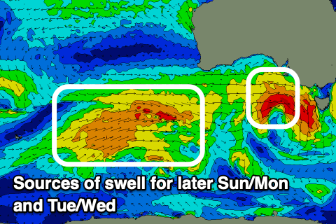
Fun run for both regions
South Australian Forecast by Craig Brokensha (issued Friday September 27th)
Best Days: Today, tomorrow morning South Coast, Monday morning South Coast, Mid Coast Tuesday, both coasts Wednesday, South Coast Thursday
Features of the Forecast (tl;dr)
- Fading swell tomorrow with fresh N/NE winds, possibly strong at times
- Small-moderate sized W/SW swell building Sun with fresh W-W/SW winds (W/NW morning South Coast)
- Swell peaking Mon AM with W/NW tending SW winds
- Moderate sized SW swell building Tue, peaking Wed
- Variable winds on the Mid Coast Tue, W/NW tending SW then S down South
- Local offshore winds Wed AM (E/NE South Coast), tending variable on the Mid and fresh S/SE down South
- Easing swell Thu with NE tending SE winds
Recap
The new pulse of W/SW swell expected yesterday came in at a fun 1-2ft all day across the Mid Coast with favourable conditions, while the South Coast improved steadily with better than expected winds. A strong pulse of S’ly swell was also seen, generated by a tight low that spawned south of us on Wednesday.
Today we’ve got better offshore winds but a bit of surface lump to iron out with a mid-period S/SW swell to 3ft to occasionally 4ft while the Mid Coast has dropped to a still fun 1.5ft.
This weekend and next week (Sep 28 - Oct 4)
Our current mix of W/SW and S/SW swells will ease into the weekend with small 2ft waves fading across Middleton tomorrow morning, tiny and unsurfable inside the gulf.
A fresh to possibly at times strong N/NE wind will favour the South Coast, with Sunday seeing a W-W/SW change moving through (W/NW early) down Sout but tiny.
As touched on in Wednesday’s update, this change will be attached to a healthy front with a building mid-period W/SW swell due into the afternoon across both coasts, reaching 2ft inside the gulf and 2-3ft down South later, with Monday seeing a peak in size to 3ft across Middleton.

Winds will be favourable for the South Coast (bumpy Mid) and W/NW on Monday morning before shifting W/SW into the afternoon but without much strength.
We then look at the stronger frontal progression moving in behind Sunday’s system. This looks to be a much better swell producer though not as strong as earlier forecast, with a fetch of strong to gale-force W/SW winds expected to project under the country, through our south-western swell window from Monday through Tuesday.
A moderate + sized mid-period swell is due, building Tuesday afternoon but with a peak in energy on Wednesday.
The direction looks best for the South Coast but the Mid should still see small waves, with the peak on Wednesday 2ft (1-2ft Tuesday), with Middleton coming in at 4-5ft.
Local winds on Tuesday look light for the Mid Coast and favourable, with the South Coast seeing dawn W/NW tending SW then S winds, best Wednesday with light, local offshore winds across both regions (lumpy South Coast), with variable sea breezes on the Mid, fresher S/SE down South.
Thursday and Friday will be best for the South Coast as the swell eases under NE tending SE winds on the former, N/NE Friday but small.
Longer term the outlook is tricky with divergent model guidance regarding instability moving in from the Indian Ocean. More on this Monday. Have a great weekend!

