Trickier wind outlook developing for the South Coast
South Australian Forecast by Craig Brokensha (issued Monday September 23rd)
Best Days: South Coast today, Mid Coast this afternoon, both coasts tomorrow morning (South Coast all day), South Coast Saturday
Features of the Forecast (tl;dr)
- Large mix of easing SW groundswell tomorrow AM, and reinforcing SW groundswell
- Light, local offshore tending N winds inside the gulf tomorrow, light, local offshore tending variable South Coast
- Easing swell Wed with strengthening SW tending S/SE winds down South (S/SE all day Mid Coast)
- Small mix of W/SW and S/SW swells Thu with strong S/SE winds
- New mid-period S/SW swell Fri with E/NE tending SE winds
- Small, easing surf Sat with fresh N/NE winds
Recap
Friday’s large pulse of SW groundswell held well into Saturday morning with clean conditions around Victor as 6-8ft sets thundered into the magnets. The swell eased through the day with yesterday coming in smaller but nice and clean again.
The Mid Coast offered bumpy/choppy waves all weekend for the desperate.
Today we’ve got our secondary pulse of large SW groundswell in the water with sets to 8ft across the region under a light offshore wind while the Mid Coast is a bit cleaner though still bumpy/lumpy and to 1-2ft. We should see the afternoon offering the best waves and conditions as winds ease and tend more variable inside the gulf.
This week and weekend (Sep 24 - 29)
The coming period ahead isn’t anywhere near as active and as favourable as what we’ve currently seen for the start of spring as the patterns settle down into a more typical spring outlook for this week/weekend.
Today’s large SW groundswell which was generated by a strong polar low projecting a fetch of severe-gale to storm-force SW winds towards us over the weekend will ease tomorrow.

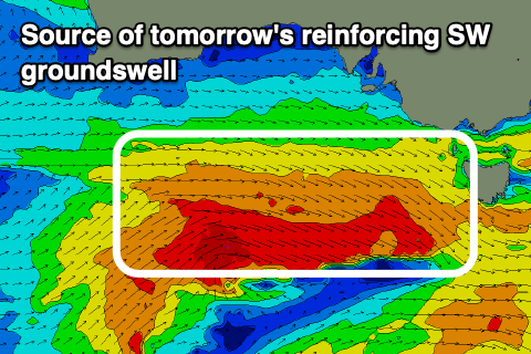
The secondary pulse of large, reinforcing SW groundswell for tomorrow morning has been downgraded a touch owing to the swell generating fetch of W/NW winds only reaching gale to severe-gale and later in our swell window.
With this we can still likely expect surf to 6ft+ across the South Coast, easing through the day while the Mid Coast looks to be mostly around 1-2ft.
Conditions will be favourable across both coasts tomorrow morning with light, local offshore winds, tending variable down South but freshening from the N’th inside the gulf, so go early.
Wednesday will then be a lay day with a trough due to bring a strengthening SW tending S/SE change across the South Coast, cleaner inside the gulf but tiny and easing from 1-1.5ft.
Thursday will remain average as the swell holds the 1-1.5ft range across the Mid Coast along with strong S/SE winds down South, improving slightly Friday as winds shift E/NE through the morning.

There’ll likely be a lot of lump and randomness in the mix, but there’ll also be a small-moderate sized mid-period S/SW swell in the water, generated by a weak but healthy polar front projecting up towards us, south-west of Tasmania on Wednesday.
The South Coast should come in at 3ft across Middleton, tiny inside the gulf and fading from 1ft, with Saturday looking smaller and cleaner with a fresher N/NE offshore wind across the South Coast.
Following this there’s nothing major on the cards until Tuesday/Wednesday onwards next week when we may see a mid-latitude frontal system bringing a fun sized W/SW swell. Winds are dicey but check back here Wednesday/Friday for the latest.

