Large episodic winter swells
South Australian Forecast by Craig Brokensha (issued Wednesday August 28th)
Best Days: Mid Coast dawn tomorrow, Mid Coast Monday afternoon and dawn Tuesday, South Coast all period besides Monday
Features of the Forecast (tl;dr)
- Large W/SW SW groundswell building later today, easing from a peak early tomorrow, smaller Fri
- Moderate N/NW winds tomorrow, strengthening into the PM (N/NE early Mid Coast)
- Strengthening W/NW winds Fri (building windswell across the Mid Coast)
- Large, powerful W/SW groundswell building Sat PM, peaking overnight, easing Sun AM with a reinforcing pulse for later Sun and Mon AM
- Strong W/NW winds Sat/Sun
- Strong but rapidly easing SW winds Mon, tending light W/SW across the Mid into the PM
- Freshening N/NE tending N/NW winds Tue (NE early on the Mid Coast)
- Mod-large SW groundswell for Tue PM, easing Wed with strong N/NW tending NW winds
Recap
The Mid Coast offered a window of OK conditions and 2-3ft of swell yesterday at dawn before the tide claimed it along with strengthening N’ly winds by mid-morning. The South Coast was 2-3ft early but eased through the day as strengthening offshore winds made for tricky conditions.
Today we’ve got our first pulse of large W/SW groundswell on the build with choppy 3-4ft sets inside the gulf and 4-5ft sets across the South Coast. We should see the swell building to the 6ft+ range later today down South as winds hold from the W/NW.
This week and next (Aug 29 - Sep 6)
Here we go.

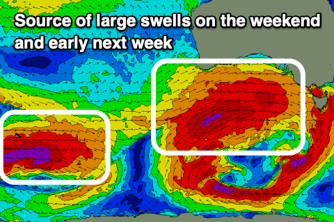
We’ve got a large, windy run of surf on the cards, starting from today with all the activity that’s been focussed across the southern Indian Ocean finally being dragged east by a strong node of the Long Wave Trough.
Today’s initial frontal system is generating a great fetch of gale to severe-gale W/SW winds, with a peak in large SW groundswell due tomorrow morning to 6ft to occasionally 8ft across the South Coast, holding 3ft to occasionally 4ft across the Mid Coast.
A drop in swell is due through the day with Friday coming in at a smaller 3-4ft across Middleton.
Winds will ease and shift N/NW tomorrow morning (tending N/NE across the Mid Coast early) before restrengthening from the N/NW into the afternoon, becoming even stronger from the W/NW Friday as the next swell generating front moves in, kicking up a late increase ins stormy swell to 3-4ft inside the gulf.
The next swell generating system will be attached to a broad, southern ocean gyre, with multiple frontal systems spinning around it from Friday through the weekend.
The first frontal system looks the strongest and most significant, with a fetch of severe-gale winds with embedded storm-force bursts due to project towards and across us through Friday.

A large, long-period W/SW groundswell is due from this front, building through Saturday, peaking later/overnight, easing Sunday.
We’ll then see a secondary, more zonal fetch of severe-gale W’ly winds generating a large, reinforcing groundswell for Sunday afternoon and Monday morning.
Size wise, the South Coast looks to build to 8ft+ later Saturday, easing from a similar size Sunday morning with the reinforcing energy maintaining 8ft sets later and into Monday morning.
The Mid Coast looks to hold the 4ft range from Saturday afternoon through Sunday, easing from 3-4ft on Monday.
Local winds on the weekend will favour protected spots, and be strong from the W/NW both Saturday and Sunday, with Monday seeing strong but quickly easing SW winds, tending lighter W/SW into the afternoon across the Mid Coast and variable down South in the wake of one of the swell producing fronts. With this a late surf across the Mid Coast is worth pencling in.
Into Tuesday, one final pulse of SW groundswell is due into the afternoon, easing Wednesday morning.
The source will be a trailing but strong frontal system moving under the country early next week, generating a fetch of severe-gale W/NW winds.
4-6ft sets are likely to persist across the South Coast with easing 2-3ft sets across the Mid Coast along with freshening N/NE tending N/NW winds (NE-N/NE early inside the gulf.)
Looking at the end of the week, moderate sized surf is still due with favourable winds for the South Coast, but more on this Friday.


Comments
I wonder if we will see a new river mouth formed at Southport?