Large, windy surf incoming

South Australian Forecast by Craig Brokensha (issued Monday August 26th)
Best Days: Mid Coast this morning, South Coast Wednesday through Sunday, Mid Coast Monday next week
Features of the Forecast (tl;dr)
- Easing swell tomorrow with strengthening N/NW winds (N/NE early Mid Coast)
- New W/SW groundswell for tomorrow PM, peaking Wed AM
- Larger W/SW groundswell building Wed PM, peaking Thu AM, easing and smaller Fri
- Strong W/NW-W winds Wed, fresh NW tending N/NW Thu
- Strengthening W/NW winds Fri
- Large W/SW groundswell building Sat PM, peaking Sun AM with a larger pulse for later Sun and Mon AM
- Strong W/NW winds Sat/Sun
- Mod-fresh S/SW winds Mon, possibly S/SE early Mid Coast
Recap
Friday’s swell eased back into the weekend with Saturday offering the best conditions before the swell bottomed out yesterday. The Mid Coast saw a small W’ly swell yesterday with early OK winds, deteriorating through the day.
Today we’ve got our fresh pulse of acute W’ly swell with a window of lighter winds inside the gulf and lumpy, solid 3ft surf, too west for the South Coast with small, wind affected waves.

Sizey surf this morning
This week and weekend (Aug 27 - Sep 1)
Better late than never?
We’re finally looking at an outlook that’s generally expected through the middle of winter, with all the strong activity that’s been primarily focussed in the Indian Ocean finally moving east more towards the south-east of the country.
With this we’re set to see multiple, significant swell generating systems firing up through our swell windows, producing a large, extended run of surf for both regions, though the winds will favour the South Coast over the Mid Coast.
First, looking at tomorrow and our current pulse of W’ly swell is due to ease into tomorrow morning, but a new pulse of W/SW groundswell is due to replace it, produced by a poorly aligned but significant fetch of severe-gale to storm-force W/NW-NW winds passing under Western Australia today.
With this we should see 2-3ft sets maintained inside the gulf, while Middleton looks to start slow and to 1-2ft max, with the groundswell building to 3ft into the afternoon.
Strengthening N/NW winds will favour the South Coast while adding lots of chops and bumps inside the gulf (moderate to fresh N/NE early).

Now, moving into Wednesday and a significant, strengthening frontal system pushing in from under Western Australia will clip us, while also bringing a moderate to large sized spike of W/SW groundswell, building into the afternoon, peaking Thursday morning.
Fetches of gale-force W/SW winds should kick up 6ft of surf later in the day Wednesday across Middleton, 3ft inside the gulf with a peak Thursday to 6ft to occasionally 8ft down South and 3ft to occasionally 4ft inside the gulf.
Strong W/NW-W winds are due on Wednesday with Thursday seeing excellent, moderate to fresh NW tending N/NW winds.
Friday will be smaller and half the size of Thursday morning as strengthening W/NW winds favour protected spots down South.
This will be ahead of the next swell generating storm, with that being another broad, expansive fetch of W/SW gales setting up under the country, surging towards us during Friday, followed by a secondary, stronger fetch of severe-gale W/SW tending W/NW winds moving in on top of the active sea state Saturday/Sunday.
What we should see from these developments is a large W/SW groundswell building Saturday, reaching 6ft to possibly 8ft on dark and into Sunday morning down South, with 3ft to occasionally 4ft waves across the Mid Coast.
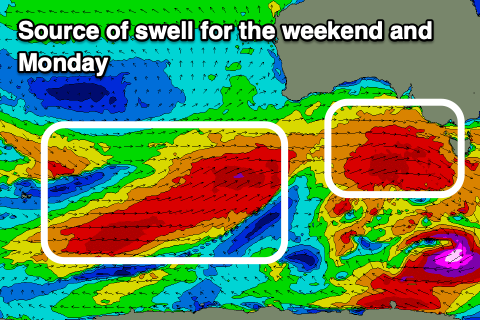
The stronger surge of severe-gales looks to generate a larger pulse of swell for later Sunday/Monday morning to 8ft across Middleton with the Mid Coast holding that 3-4ft range, easing into the middle of next week.
Local winds will favour protected spots down South with strong W/NW breezes on both Saturday and Sunday, shifting S/SW on Monday and weakening on the backside of all the activity. We may see early S/SE winds inside the gulf but check back here on Wednesday and Friday for any changes to the expected peak in size and local winds.
Longer term, the activity looks to settle a little into next week but with great conditions continuing for the South Coast. See you back here Wednesday.
Comments
Good, we need to stir up the sand around at Waits/Parsons because it's been straight-hander city.
When you say great conditions for the south coast next week are we talking light northerlies from Tuesday to Friday next week? I have the week off...
Tuesday and Wednesday northerly at this stage.
Excellent thanks.