More active period ahead
South Australian Forecast by Craig Brokensha (issued Wednesday August 21st)
Best Days: Late tomorrow both coasts, Friday South Coast (early Mid Coast), South Coast Saturday and Sunday, South Coast all next week
Features of the Forecast (tl;dr)
- Late increase in small, W/SW groundswell today, peaking tomorrow AM with W/NW-NW tending variable winds later tomorrow
- Late pulse of moderate sized SW swell Thu, peaking Fri AM
- Strengthening N/NE winds Fri, weaker NE early on the Mid
- Easing swell Sat with W/NW tending N/NW winds
- New W'ly pulse Sun with strengthening N/NW tending W/NW winds
- Plenty of swell next week with winds from the western quadrant
Recap
The surf’s been average across both coasts the last two days with small to tiny waves down South and choppy conditions inside the gulf.
This week and weekend (Aug 22 - 25)
Later today but more so tomorrow our secondary pulse of very long-range W/SW groundswell is due, generated by a distant storm that developed to the south-east of South Africa last week.
No real size is due from this source with tiny 1-1.5ft sets inside the gulf, a slow 2ft across Middleton along with W/NW-NW winds, tending NE on dark inside the gulf.

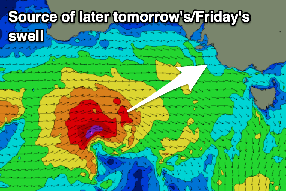
Of greater importance is the pulse of W/SW-SW swell for later in the day and more so Friday morning, with a strong, tight mid-latitude low that’s currently under Western Australia, heading east, under us.
A small fetch of gale to severe-gale W’ly winds should generate a short-lived but good spike of SW swell for later tomorrow to 1-2ft inside the gulf and 3-4ft off Middleton, peaking Friday morning to 4ft+ with the Mid Coast seeing slower 2ft sets. The swell should then ease into the afternoon, down steadily through the weekend from 2-3ft down South, tiny inside the gulf.
Local winds will favour the South Coast Friday and be moderate to fresh from the N/NE, NE inside the gulf adding small chops and bumps, worsening into the afternoon as winds strengthen.
The South Coast will again be the pick on Saturday with fresh W/NW tending NW-N/NW winds as the swell eases.
Moving into Sunday, a short-lived pulse of W’ly swell is due, generated by a strong but short-lived burst of strong to gale-force W’ly winds under Western Australia on Friday as a front quickly dips south-east through our swell window.
A kick to 2ft to possibly 3ft is likely inside the gulf from this source, similar across Middleton but with strengthening N/NW tending W/NW winds as the next, more robust swell generating front moves in.

This system and following activity next week will finally be the result of all the action in the Indian Ocean shifting east more towards us.
This should bring large pulses of W/SW-SW groundswell next week along with winds out of the western quadrant but we’ll look at this in more detail on Friday.
Firstly, Sunday’s front should bring some short-range W’ly swell Monday under gusty W/NW winds with larger surf due later week. See you back here Friday.


Comments
Relentless west swells