Easing surf ahead of a new spike in swell later week
South Australian Forecast by Craig Brokensha (issued Monday August 19th)
Best Days: South Coast early tomorrow, later Thursday both coasts, Friday morning both coasts, Saturday morning South Coast
Features of the Forecast (tl;dr)
- Easing W/SW swell tomorrow with fresh N/NE tending strong NW winds, W/NW later
- Low point in swell early Wed with W/NW-NW winds
- Late increase in small, W/SW groundswell Wed, peaking Thu AM with W/NW-NW tending variable later
- Late pulse of moderate sized SW swell Thu, peaking Fri AM
- Local offshore winds Fri AM (E Mid Coast, N South Coast), tending E/NE down South into the PM, N/NE inside the gulf
- Easing swell Sat with N/NW winds ahead of a shallow change
- Smaller Sun with strengthening N/NE tending W/NW winds
Recap
Saturday was a lay day with onshore winds across the Mid Coast and a poor, localised swell while the South Coast offered morning W’ly winds but a weak, small swell.
The low linked to Saturday’s winds and swell cleared east yesterday as some new S’ly swell filled in down South and the Mid cleaned up.
The Mid Coast saw tiny but fun 1-1.5ft waves with Middleton coming in at a better 3ft or so.
Today we’ve got our inconsistent, long-range W/SW groundswell in the water along with fresher NE winds. The South Coast is 2-3ft or so while the Mid Coast isn’t really seeing much with slow 1-1.5ft sets max (yesterday was better).
This week and weekend (Aug 20 - 23)
Tomorrow will favour the South Coast magnets as today’s inconsistent W/SW groundswell eases under a fresh N/NE tending stronger NW wind, W/NW later.
This shift in wind will be thanks to a high riding front moving across us, with no major swell due from it into Wednesday as winds hold out of the W/NW-NW.

Later in the day Wednesday but more so Thursday, our secondary pulse of very inconsistent, long-range swell is due. This was generated near South Africa and isn’t expected to offer much over 2ft across Middleton with tiny 1.5ft waves inside the gulf.
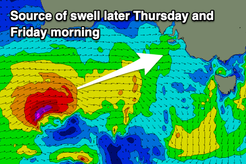
Of greater interest is a strengthening mid-latitude low moving in from the west over the coming days, with a good but tight fetch of W’ly gales (with bursts of embedded gales) due to generate a fun spike in swell for later Thursday and Friday morning.
It’ll be a short-lived spike but we should see Middleton kicking to 3-4ft later Thursday, easing from the 4ft+ range on Friday morning with the Mid Coast coming in at 2ft.
Winds on Thursday look W/NW-NW during the morning, tending more variable through the afternoon, with Friday being the pick thanks to local offshore morning winds, tending E/NE down South into the afternoon and N/NE inside the gulf.
The swell will back off into the weekend under offshore N/NW winds down South, shifting onshore but without much strength into the afternoon, while Sunday looks to see strengthening N/NE winds ahead of a W/NW change ahead of a high riding frontal system across the country.
This frontal system looks to bring with it some localised windswell early week, but beyond this - increasing winds and swell are due from mid-week as all the activity from the Indian Ocean finally starts moving further east towards us. More on this Wednesday.

