Tricky, average weekend, a bit more workable next week
South Australian Forecast by Craig Brokensha (issued Friday August 16th)
Best Days: Mid Coast possibly late Sunday but more so Monday, South Coast selected spots Monday and Tuesday morning, Friday
Features of the Forecast (tl;dr)
- Weak W swell Sat with strong W/SW tending SW winds (likely W/NW early Victor but tiny)
- Fading W swell Sun with a small, weak S pulse down South
- Light, local offshore tending weak sea breezy Sun
- Moderate + sized W/SW groundswell for later Sun, peaking Mon with strong NE winds
- Easing swell Tue with strong N tending NW winds
- Weak W windsswell Wed with mod-fresh W/NW tending NW winds
- Inconsistent W/SW groundswell Thu with SW tending SW winds
- Moderate sized SW swell later Thu, peaking Fri with NE winds
Recap
Wednesday’s good pulse of W/SW swell eased back through yesterday with wind affected 2ft+ waves across the Mid Coast that improved into the afternoon as winds eased, small and fun down South all day to 2ft across Middleton.
Today the swell was tiny across the Mid Coast with a building windswell from strengthening N/NW winds, small and clean down South.
This weekend and next week (Aug 17 - 23)
The weekend is more miss than hit right now.
Today’s strengthening winds are linked to a strong mid-latitude low moving in from the west, with it currently generating a fetch of strong W/SW winds directly west of us.
This should generate a short-range W’ly swell for tomorrow to 2ft or so with no real size down South.
Winds will still be strong from the W/SW tomorrow morning (possibly W/NW early around Victor but with no size), tending SW through the day.

Sunday should then see variable offshore winds with fading 1-1.5ft waves inside the Mid Coast while the South Coast only looks to come in at a weak 2-3ft from the southern side of the low as it moves across us. This swell was looking better on Wednesday but has since been downgraded.
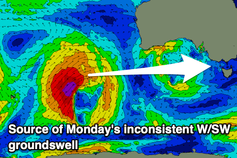
Now, into later Sunday but more so Monday our new W/SW groundswell from the strong low in the Indian Ocean is due, with no changes to the expected size since Wednesday.
It’ll be inconsistent but we should see sets to 2ft mostly across the Mid Coast with the odd 3ft’er possibly on the favourable parts of the tide with the South Coast coming in at 3-4ft from Day St to Cliffs, further east.
Winds will be tricky across the Mid Coast with strong E/NE tending NE breezes, favouring some spots over others with strong NE winds blowing all day down South.
Stronger N tending NW winds on Tuesday will then favour the South Coast as the swell eases.
The frontal system linked to the shift and strengthening of winds is very weak and with this only a tiny 1-1.5ft of W’ly windswell is due Wednesday from it along with persistent moderate to fresh W/NW tending NW winds. The South Coast will be cleaner but small to tiny.

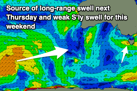
Now, into Thursday, another very long-range W/SW groundswell is due, with the source being a significant storm south of South Africa. This storm has weakened while pushing east and it’s only due to come in at a very inconsistent 2-3ft across Middleton, tiny inside the gulf and with unfavourable SW tending SE winds as a mid-latitude front clips us.
The front should generate some better mid-period SW swell for later in the day Thursday but more so Friday morning to what looks to be at this stage 3-4ft across Middleton and 1-2ft on the Mid Coast.
Thanks to the front clearing quickly east, winds should swing back to the NE on Friday but we’ll review this Monday.
Longer term the storm activity in the Indian Ocean looks to move more east into the following week, hopefully bringing better swells for the South Coast. See you back here Monday though. Have a great weekend!

