More west swell but with less favourable winds for the gulf
South Australian Forecast by Craig Brokensha (issued Wednesday August 14th)
Best Days: Today Mid Coast, early tomorrow Mid Coast, South Coast tomorrow morning, Monday both coasts, Tuesday and Wednesday South Coast
Features of the Forecast (tl;dr)
- Moderate + size W/SW swell for today (peaking PM), easing tomorrow with fresh N/NE tending stronger N-N/NW winds
- Strong NW tending W/NW winds Fri with small to tiny leftovers and a building windswell on the Mid Coast
- Weak W swell Sat with strong W/SW tending SW winds
- Fading W swell Sun with a new S pulse down South
- Light E/SE-SE tending S/SE winds Sun
- Moderate + sized W/SW groundswell for later Sun, peaking Mon with strong NE winds
- Secondary moderate + sized W swell building Tue, peaking Wed with gusty NW tending W/NW winds Tue, W/NW tending N/NW Wed
Recap
Yesterday started wind affected and small to tiny across both regions, but a new W/SW groundswell offered 2ft sets into the afternoon across the Mid as winds tended variable, with our stronger and better pulse of mid-period energy filling in this morning, providing sets to 2ft+ but with bumpy conditions.
We should see the swell peaking to 2-3ft this afternoon (already there) as winds go variable, while the South Coast will remain on the smaller side.

New swell with forecast variable winds yesterday afternoon
This week and next (Aug 15 - 23)
Today’s pulse of good W/SW swell is due to start easing tomorrow but still come in at 2ft+ on the favourable parts of the tide with 2ft+ sets across Middleton.
Winds will freshen from the N/NE tomorrow creating deteriorating conditions inside the gulf, best down South, strengthening further from the N-N/NW into the afternoon.
Come Friday as the swell bottoms out, stronger NW tending W/NW winds will leave no real quality options down South while kicking up a windswell inside the gulf.
Now, this wind will be thanks to a broad but not overly strong and north (in position) mid-latitude low moving in from the west, with the swell potential being mainly weak thanks to strong W/SW winds being generated immediately west of us in the Bight.
This fetch on Friday should kick up a 2ft wave for Saturday, but with a very low period, while a fetch of S/SE winds feeding in on the southern flank should produce a weak S’ly swell for the South Coast Sunday to 3ft to maybe 4ft,
Looking at the local winds and Saturday looks poor across both regions as the low continues east across us bringing strong W/SW tending SW winds. Sunday will be cleaner across the Mid Coast with an E/SE offshore but lingering SE winds across the South Coast look to create average conditions.

Size wise the Mid Coast only looks to ease back from a tiny, weak 1-1.5ft max.
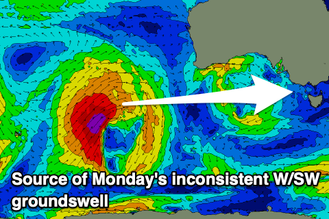
Into Monday a new pulse of moderate sized W/SW groundswell is due, followed by some close-range W’ly energy on Tuesday/Wednesday.
This groundswell is being generated by a tight low that’s formed south-east of Madagascar and is moving east while generating a fetch of severe-gale to storm-force W/SW winds.
A secondary but slightly less favourably aligned intensification as it moves closer towards Western Australia should help produce a bit of extra size.
It’ll be inconsistent but the Mid Coast should may see size kicking later in the day Sunday, peaking Monday to 2ft to possibly 3ft on the favourable parts of the tide with Middleton coming in at 3-4ft.
The remnants of this storm will then move under WA on Sunday and intensify, generating the additional W’ly swell for Tuesday afternoon/Wednesday. This looks to come at 2ft to occasionally 3ft but we’ll confirm this Friday.
Looking at the local winds and strengthening NE winds ahead of the front are expected Monday, gusty NW tending W/NW on Tuesday. Longer term there’s plenty more swell on the cards but check back here Friday.

