Great west swell all weekend, with more next week
South Australian Forecast by Craig Brokensha (issued Friday August 9th)
Best Days: Both coasts today, tomorrow and Sunday, South Coast Monday, Mid Coast Wednesday morning, South Coast Thursday
Features of the Forecast (tl;dr)
- Moderate + sized W/SW swell for later today and tomorrow with variable offshore winds, tending weak sea breezey
- Slowly easing swell Sun with local offshore tending more NE winds in the gulf, variable into the PM
- Easing swell Mon with N/NE winds
- New, inconsistent W/SW groundswell for Tue PM and Wed AM with N/NE winds Tue, variable offshore ahead of sea breezes Wed
- Moderate + size W/SW swell for later Wed and Thu with strengthening N/NE tending N winds
Recap
Wednesday’s swell eased back steadily through yesterday as strong northerly winds favoured the South Coast, best through the morning before fading into the afternoon. The Mid was tiny and choppy with the N/NW winds.
Today we’ve got our good, first pulse of building W/SW swell in the water with cleanish conditions and consistent 2ft+ waves inside the gulf, though shrouded by fog, clean down South and also around 2ft off Middleton. Spot the surfer in the fog in the below Triggs surfcam grab.
More consistent size is due into the afternoon as winds go variable onshore.

Head-high sets in the fog
This weekend and next week (Aug 10 - 16)
The west swells continue this period, and the reason is outlined in this article: Stratospheric Warming Event Comes Home To Roost
This afternoon’s increase in W/SW swell will be followed by a better, more consistent pulse of energy later in the day but more so tomorrow, generated by a healthy mid-latitude frontal system passing under WA the last couple of days
A good fetch of strong W’ly winds should provide more consistent 3ft waves across the Mid Coast tomorrow, with Middleton coming in around a similar size to 3ft+.
A trailing frontal system is generating slightly stronger but less favourably aligned W/NW winds today and this should help slow the easing trend into Sunday, dropping further Monday.
Easing sets from 2-3ft are due inside the gulf Sunday, 3ft down South, smaller Monday.

Looking at the local winds and both coasts will be great tomorrow morning with light, local offshore breezes ahead of weak afternoon sea breezes, similar Sunday but with a touch more north in the offshore across the Mid Coast, variable through the afternoon across both regions.
Monday will see strengthening N/NE winds, creating bumpy/choppy conditions inside the gulf, best down South with the fading swell.
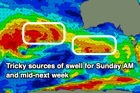
We then look at our tricky, inconsistent W/SW groundswell due Tuesday afternoon but more so Wednesday morning across the region.
The source is a very poorly aligned but strong storm in the southern Indian Ocean, with fetches of gale-force winds being essentially blocked by Western Australia.
It’ll result in an inconsistent west swell that looks to come in at 1-2ft across the Mid Coast Tuesday afternoon and Wednesday morning, 2ft or so across Middleton.
A trailing front pushing up and then under Western Australia on the weekend and Monday looks to generate a slightly better pulse for later Wednesday and Thursday more towards 2-3ft across the Mid Coast and Middleton.
Local winds Tuesday will persist out of the north, likely back to local offshore on Wednesday and strengthening N'th Thursday but we’ll review this on Monday. Have a great weekend!


Comments
Fog is still hanging around on the Mid, moody as!
https://www.swellnet.com/surfcams/triggs
Yeah was super thick all day .. haven't had it stick around all day for a long time... Was thick right up n down the coast and quite a bit inland too.
I was jealous yesterday, but we've got the fog, Robe to Portland, today, looks sticky too.