Strong west swells inbound
South Australian Surf Forecast by Craig Brokensha (issued Monday July 29th)
Best Days: South Coast this morning, both coasts tomorrow afternoon, Wednesday and Thursday, South Coast Friday
Features of the Forecast (tl;dr)
- Fading swell into tomorrow AM, ahead of a new W'ly swell later, easing Wed
- N/NE tending variable winds tomorrow, similar Wed
- Strong pulse of W/SW groundswell later Wed, peaking Thu AM, easing
- E/NE-NE tending variable winds on the Mid Thu, N/NE tending variable down South
- Strengthening N/NE-N winds on Fri with easing surf
- Moderate sized + W/SW swell building Sat with W/NW winds, easing Sun with W/NW tending SW winds
Recap
Our good pulse of W’ly swell filled in on the weekend with lumpy/bumpy conditions seen on Saturday, improving through Sunday inside the gulf with, cleaner faces to 2ft under a variable breeze (average on the morning high tide). The South Coast was also lumpy and best around Victor with 3-4ft sets.
This morning the surf has faded away across both regions, best across the magnets on the South Coast.
This week and weekend (Jul 29 - Aug 4)
These notes will be brief today as Steve covers the Olympic surfing event.
The current swell will continue to ease, bottoming out tomorrow morning as a N/NE offshore creates clean conditions on the exposed beaches.
Into the afternoon, our small pulse of W/SW swell is due, generated by a tricky aligned frontal system drifting south-east from the WA region.
The Mid Coast should see 1-2ft sets later, easing from a similar size Wednesday while the South Coast only looks to come in at 2ft across Middleton. Variable afternoon winds should create decent conditions tomorrow afternoon, with N/NE tending variable winds again Wednesday as it eases.
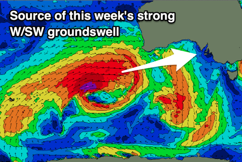
Of greater significance is the moderate to large sized pulse of W/SW groundswell for later Wednesday and Thursday morning.

The significant frontal progression linked to it is currently to the south-west of Western Australia, with a great fetch of severe-gale to storm-force W/SW winds being projected through our western swell window.
The size and strength of the progression is great and we should see the forerunners arriving through Wednesday, with a strong, late increase in size due, peaking overnight/early Thursday and then easing through the day.
The Mid Coast should come in at 3ft+ later Wednesday and Thursday morning with the South Coast offering 4-6ft surf off Middleton more so early Thursday with those light afternoon winds, N/NE tending NE on Thursday down South and E/NE-NE tending variable across the Mid Coast.
Friday is a tricky one with the swell easing as winds strengthen from the N/NE to N’th, favouring the South Coast and creating choppy conditions inside the gulf as the swell fades.
Come the weekend, a fun pulse of reinforcing W/SW swell is due Saturday afternoon, easing Sunday, generated by a weaker frontal system on the backside of the strong storm currently off WA.
The Mid Coast should pulse back to 2-3ft during Saturday afternoon and Sunday, with Middleton coming in at 3ft+ along with W/NW to SW winds on the latter.
Longer term the Indian Ocean remains active but closer to us, it’s a bit quieter. Therefore make the most of the coming week of surf.


Comments
really appreciated this confirmation on Monday, of last week's foreshadowing, craig, it allowed me to confidently position myself geographically and work-wise for limestone coast fun today/tomorrow. Just had a great, much-needed session in my old wetty, newer one is dry and dawn-ready, cheers!
Awesome, stoked!