Fun weekend, best tomorrow
South Austrlian Surf Forecast by Craig Brokensha (issued Friday July 12th)
Best Days: Tomorrow South Coast and Mid Coast, early Sunday both regions, Thursday South Coast
Features of the Forecast (tl;dr)
- Large SW groundswell for toorrow, peaking during the day, easing Sun
- Light to moderate W/NW-NW winds tomorrow AM, tending W/SW into the PM
- Early variable offshore winds Sun (W/NW South Coast), tending SW and freshening
- Strengthening S winds Mon, S/sW Tue, easing from the S/SW Wed
- Moderate sized, inconsistent W/SW groundswell Thu with mod-fresh N/NE tending N/NW winds
Recap
The Mid Coast was wild and stormy yesterday morning with 2ft+ of NW windswell but a change moved through and winds backed off quickly into the afternoon as some new W/SW energy started to show. It was a bumpy 2ft but filled up into the evening with the fast rising tide.
The South Coast was small-tiny and windy, while this morning we’ve better surf with clean conditions and 2ft sets across Middleton, while the Mid is a lumpy 1-2ft.
This weekend and next week (Jul 13 - 19)
Looking at the weekend ahead, we’ve got our large SW groundswell inbound, generated by a strong polar frontal progression pushing up towards us from the south-west of Western Australia earlier in the week.

The swell is due to be in the water during the morning tomorrow but is likely to peak through the day and we should see Middleton coming in at 6ft on the sets with 2-3ft waves on the favourable parts of the tide inside the gulf.
Winds look favourable for the South Coast with a light W/NW-NW offshore, possibly tending W/SW into the afternoon while the Mid looks dicey with a similar light to moderate W/NW tending W/SW breeze that may tend variable at times. Regardless with the swell is should still be fun.
Easing surf is then expected into Sunday from 4-5ft down South but with deteriorating conditions as early W/NW winds shift SW and freshen. The Mid Coast should see morning variable winds and easing 2ft sets.
Looking at next week, and the first half looks to be poor thanks to a low forming off the east coast of Tasmania, retro-grading back to the west, aiming gusty S/SW winds into the South Coast from Monday through Wednesday. There’s a chance for variable winds early Monday but don’t count on it. The swell will be on the ease as well.

Winds should start easing Wednesday afternoon as an approaching frontal progression towards Western Australia pushes the low to the east, and with this winds should go back to the N/NE Thursday, creating clean conditions down South.
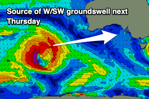
Swell wise, a new, inconsistent W/SW groundswell should be in the water, generated by a low firing up north of the Heard Island region on the weekend.
Middleton should come in around 3ft on the sets, though inconsistent with 1-2ft sets across the Mid Coast.
Longer term, the frontal activity moving in from Western Australia should finally bring some better swell energy into next weekend/the following week but check back Monday for an update. Have a great weekend!


Comments
Great to see some swell on the mid this weekend; get amongst it , Owe Danny Boy