West ahead of south-west
South Australian Surf Forecast by Craig Brokensha (issued Wednesday July 10th)
Best Days: Mid Coast later tomorrow and Friday morning, South Coast Friday morning for the keen, Saturday morning both coasts, Sunday morning both coasts
Features of the Forecast (tl;dr)
- Moderate sized W'ly swell building tomorrow PM, easing Fri
- Strong N-N/NW winds tomorrow AM, easing and tending NW and weaker SW into the PM
- N/NE winds Fri AM in the gulf, tending NW and then W/NW into the PM while freshening, NW tending W/NW winds down South
- Large SW groundswell Sat with variable tending locally offshore winds, SW into the PM
- Easing swell Sun with N/NE-NE tending W winds inside the gulf, NW tending SW down South
- Easing swell Mon with strong S/SW winds
- S/SW winds Tue/Wed with a moderate + sized S windswell
Recap
I missed a tiny W/NW swell across the Mid Coast yesterday, generated by a weak front moving through on Monday, with a kick to 1-1.5ft under variable winds. It was very close spaced and weak though, but better than flat. The South Coast was clean but tiny.
Today the swell has faded across the Mid Coast with bumpier conditions, perfect down South but still tiny.
This week and next (Jul 11 - 19)
Into tomorrow we should see our first pulse of W’ly swell energy filling in, generated by a healthy frontal system passing under Western Australia yesterday and this morning.
A good fetch of strong W’ly winds should produce a pulse to 2ft into tomorrow afternoon inside the gulf, easing back from a similar size on Friday morning.
The direction isn’t ideal for the South Coast but Middleton should also come in at 2ft (possible rare bigger one) tomorrow afternoon and Friday morning.
Looking at the local winds and strong N-N/NW breezes at dawn tomorrow will ease and then shift NW and then weaker SW into the mid-late afternoon, variable into the evening. This will create improving conditions inside the gulf, and deteriorating conditions down South.
Friday is a tricky one with morning N/NE winds in the gulf, not great but workable, shifting NW and then W/NW into the afternoon while freshening. The South Coast should see NW tending W/NW winds.
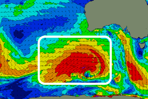
These winds will be ahead of the remnants of a significant polar frontal progression moving south of us, with a large SW groundswell to follow into Saturday.

The progression is currently positioned just east of the Heard Island region, with a great fetch of W/SW gales being projected towards us today (left), easing a little through tomorrow and becoming smaller in scope.
The swell should arrive Saturday morning, peaking through the day to a good 6ft across Middleton with 2ft to occasionally 3ft sets inside the gulf with what looks to be variable morning winds across both regions, tending locally offshore but then SW through the day.
Sunday morning looks similar but with a N/NE-NE breeze inside the gulf, NW down South as the SW groundswell starts easing back from 4-5ft across Middleton and 2ft inside the gulf.
Make the most of these light winds and fun level of swell as a trough is due to move east across us Sunday evening, bringing strong S/SW winds Monday as the swell continues to ease.
S/SW winds look to persist through Tuesday and Wednesday as the trough forms a low just east of Tasmania instead of migrating further east. Moderate + sized levels of weak S/SW windswell will accompany the onshore winds, possibly cleaning up later week as winds tip W/NW.
More on this Friday and next week.

