Larger swell for the weekend, cleanest down South
South Australian Surf Forecast by Craig Brokensha (issued Monday July 8th)
Best Days: South Coast this morning, Mid Coas for the keen later Thursday, South Coast Saturday, Mid Coast Sunday morning
Features of the Forecast (tl;dr)
- Low point in swell over the coming days
- Moderate sized W swell for Thu PM and Fri AM
- Strong N/NW winds Thu AM, tending W/SW and easing into the PM
- W/NW-NW winds Fri (possibly variable early on the Mid)
- Large SW groundswell filling in Sat, peaking through the day, easing Sun
- Moderate to fresh W/NW-NW winds Sat, SW tending S/SE Sun (possibly W/NW early around Victor and S/SE on the Mid)
- Easing swell Mon and Tue with light E/SE-E/NE winds in the AM
Recap
A good pulse of new SW groundswell provided 4ft surf across Middleton on Saturday with enough north in the wind to create clean conditions. The Mid Coast faded back from a slow 1ft with the west swell from Friday dropping away.
Yesterday was cleaner down South with easing levels of swell from the 3ft range across Middleton, tiny in the gulf, smaller and 2ft this morning down South with a glancing S/SW swell that will fade through the day.
This week and weekend (Jul 9 - 14)
The current swell will bottom out over the coming days, with the next increase in energy due out of the west on Thursday/Friday.
Now that the strong high that’s been dominating our swell window is now moving east, we’re seeing a flurry of strengthening frontal activity pushing up and towards Western Australia.

This will continue over the coming days, gaining ground on our state as it pushes the further east and out of the Tasman Sea.
With this we’re expected to see building levels of initially westerly swell energy, followed by what looks to be now a large SW groundswell for the weekend.
The first pulse of west swell for Thursday afternoon and Friday morning will be generated by a weak front passing under Western Australia tomorrow.
A broad fetch of strong W’ly winds will be generated with the Mid Coast due to come in at 2ft on the favourable parts of the tide while Middleton only looks to come in around 2ft or so thanks to the west direction.
Strong N/NW winds will create choppy surf early Thursday, easing and tending W/SW into the afternoon, while Friday morning may see early variable winds before freshening from the W/NW during the day.
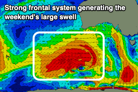
On the weekend we’re looking at a much better pulse of SW groundswell, generated by a more significant polar frontal system firing up behind tomorrow’s weak front.
A vast area of W/SW gales are forecast to be projected up and towards us through the middle to end of the week, with a large SW groundswell due to arrive early Saturday morning, peaking through the day.

Middleton should come in at 5-6ft while the Mid Coast should also see 2ft waves, with both easing Sunday from 4-5ft and 1-2ft respectively.
Thanks to the swell generating front weakening while pushing closer to us over the weekend, we’re looking at favourable W/NW-NW winds across the South Coast Saturday, possibly variable early in the gulf, while Sunday looks dicey as we fall under the backside of the progression, bringing dawn W/NW winds, tending SW quickly and then S/SE into the afternoon.
The Mid Coast may see early S/SE winds but we’ll confirm this on Wednesday and Friday.
Easing levels of swell with lighter winds from the E are due into early next week but check back here Wednesday for confirmation.


Comments
Looks like I missed a little W/NW swell from yesterday's front. It's 1-1.5ft in the gulf but close-spaced and a bit weak.