Easing Mid Coast waves with some new swell for the South Coast
South Australian Surf Forecast by Craig Brokensha (issued Friday July 5th)
Best Days: Mid Coast today, selected spots South Coast tomorrow morning, South Coast Sunday morning, South Coast Monday morning
Features of the Forecast (tl;dr)
- Easing W/SW swell tomorrow with a moderate sized, inconsistent SW groundswell for the AM, easing
- Smaller, fading surf Sun
- Fresh E/NE-NE tending weaker E/SE winds tomorrow, fresh NE tending E/NE winds Sun
- Small, inconsistent S/SW swell Mon AM, tiny into the PM
- Mod-fresh N/NE tending weaker N/NW-NW winds Mon
- Small W'ly swell Wed and Thu with some larger NW windswell building Thu with strengthening N tending NW winds
- Mod-large W/SW-SW swell later next week/weekend with W/NW-SW winds
Recap
Our new pulses of inconsistent W/SW groundswell only showed slowly through yesterday with building sets to 1-1.5ft before the tide swallowed the energy into the afternoon.
The South Coast was lumpy and small before building to 3ft into the afternoon with workable sea breezes.
Today the swell is showing better with 2ft sets in the gulf, 3-4ft down South as east winds favour the Mid Coast.

Fun sets this morning
This weekend and next week (Jul 6 - 12)
Today’s W/SW swell energy will fade back through tomorrow with the Mid Coast coming in at a less consistent 1ft to occasionally 2ft on the favourable parts of the tide while the South Coast should be a good pulse of SW groundswell (possibly showing later today). This was generated by a great fetch of severe-gale W/NW winds moving towards the polar shelf and should come in at 4ft+ across Middleton, easing through the day and then down from 2ft to occasionally 3ft Sunday morning.
Winds will be coming out of the E/NE-NE tomorrow morning, fresh in nature favouring some spots but not others, tending weaker E/SE into the afternoon.

Sunday looks similar with fresh NE winds, tending E/NE into the afternoon, favouring selected spots over others.
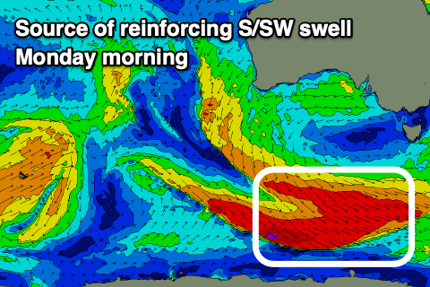
Into Monday, a small reinforcing pulse of mid-period S/SW swell is due, generated from a secondary front generating weaker W/NW winds moving off axis through our swell window over the coming days.
Inconsistent 2ft waves should persist across Middleton early Monday morning, easing through the day and tiny Tuesday. Winds will be better Monday and moderate to fresh N/NE tending weaker N/NW-NW into the afternoon but with the surf becoming tiny.
There’s nothing significant to follow swell wise until later next week and more so the weekend as a strong frontal progression starts moving in from the west.
The progression will try and move in early next week but be deflected to the south-east, with a stronger push due mid-late week generating moderate to large levels of W/SW swell.
A couple of weak fronts passing under WA early week may generate some small swell for the Mid Coast Wednesday/Thursday to 1-2ft but with poor strengthening N winds, shifting W/NW on Thursday kicking up some larger stormy swell.
Better levels of swell should fill in Friday/Saturday with a bit of SW in direction along with what looks to be workable winds. More on this Monday. Have a great weekend!


Comments
Seabreeze wasn't expected?
Expected S/SE-SE winds this arvo, look light and not doing any real damage. Expect offshores to kick back in soon.
There they are.
Didn't last long unfortunately now back to the dreaded easterly
I think he was referring to the Mid :)
Am i reading this right? Ssw swell from a strong W/ Norwester,that is so weird. If there are gale force SW winds in the Southern Ocean,what would the resultant swell direction be?
Yeah radial spread and side-band energy just spreads up from that direction but with less size and consistency.