Strong west swells inbound
South Australian Surf Forecast by Craig Brokensha (issued Monday May 27th)
Best Days: Today South Coast, tomorrow both coasts, Wednesday through Sunday South Coast, Mid Coast Saturday
Features of the Forecast (tl;dr)
- Moderate + sized pulse of W'ly swell later today, peaking tomorrow AM
- Larger W'ly groundswell later tomorrow, peaking Wed AM
- Moderate N/NE tending lighter N/NW winds tomorrow
- Fresh N/NE tending N/NW winds Wed
- Strong N tending N/NW winds Thu with a moderate sized NW windswell building
- Stormy W/SW swell Fri with strong W/NW winds, easing later
- Building swell across the South Coast later Fri, easing Sat
- Variable winds possibly Sat
- Easing swell Sun with N winds
Recap
The weekend offered easing levels of swell from Friday afternoon with good conditions across the South Coast, coming in at 3ft+ across Middleton, smaller yesterday and back to the 2ft range.
This morning, an inconsistent groundswell is providing slow 3ft sets with excellent conditions under a light offshore wind. The Mid Coast was tiny all weekend though 1ft today.

New pumping swell this AM
This week and weekend (May 28 - Jun 2)
West, west, west.
We’ve got a weather pattern shift underway across the west of the country, with a series of back to back storms rolling in generating tricky westerly swells for the coming week.
This looks to remain the theme through the coming forecast period as a strong node of the Long Wave Trough peaks near Western Australia, resulting in storms pushing northwards in latitude, which is through our western swell window, less favourable for the South Coast.
The main issue is the shadowing effects of Kangaroo Island, decreasing the consistency and size the further west the swell shifts.
So keep this in mind when surfing over the coming week or so and keep your expectations in check.
Coming back to late today’s and tomorrow morning’s surf, and the first pulse of W’ly swell is due to arrive, generated by an initially strong but weakening mid-latitude front pushing towards and under WA on the weekend.
This system is currently weakening south-west of us, with the swell due to peak tomorrow morning to 2ft to occasionally 3ft across the Mid Coast, with inconsistent 2-3ft sets across Middleton.
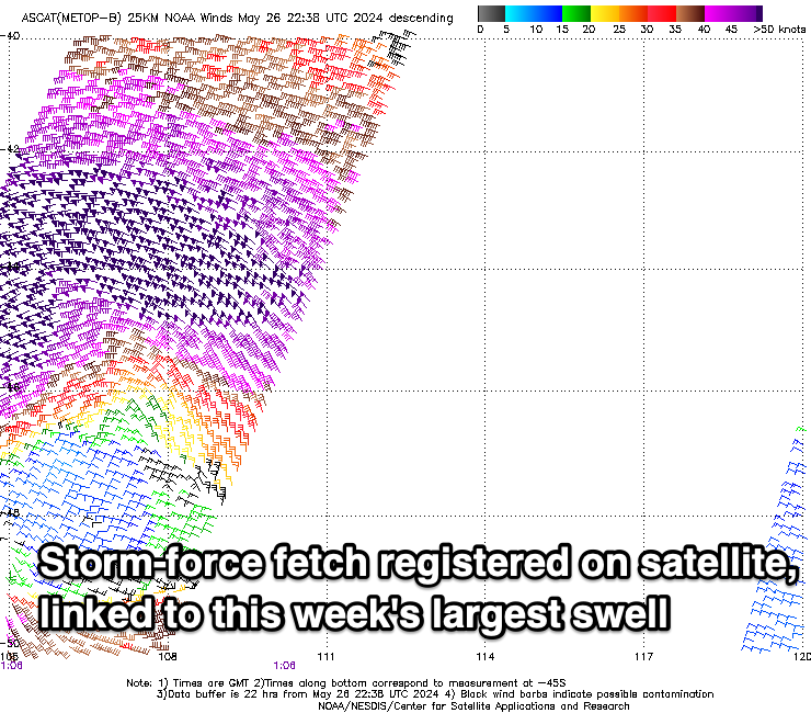
Into the late afternoon but more so Wednesday morning, our stronger pulse of W/SW groundswell is due, thanks to a strong low firing up in the same spot as the weaker front before it.

This low generated a fetch of severe-gale to storm-force W/SW winds in our western swell window, with it now weakening while dipping south-east, a little more favourably aligned in the South Coast’s swell window.
We should see a large sized W/SW groundswell arriving later tomorrow, possibly reaching a stronger 3ft on the Mid Coast by dark, though hindered by the high tide, with Wednesday due to see 3ft+ sets on the favourable parts of the tide, with Middleton coming in at 4-6ft.
Looking at the local winds and a NE tending N/NE then N/NW breeze is due across the Mid Coast tomorrow, adding small bumps and ridges, while creating excellent conditions all day down South.
Wednesday will then becoming choppy in the gulf with freshening N/NE tending N/NW winds, worse Thursday with stronger N tending N/NW breezes ahead of a deepening mid-latitude low in the Bight.
Now, the models diverge a little regarding the strength and positioning of this system but regardless it looks like we’ll see building NW windswell later Thursday to 3ft in the gulf, while the South Coast looks to ease back from 3ft on the sets.
A shift in winds to the W/NW on Friday is due, remaining strong in nature, with the Mid Coast continuing in the stormy 3ft range, while the South Coast should see some close-range swell building into the afternoon, reaching 3-4ft and best inside protected spots, though slower here.
Saturday may see more variable winds as a trough slips through Friday evening and a high starts to fill in, but we’ll have to review this on Wednesday. The swell looks to ease, with Sunday coming smaller under N’ly winds.
Following this, further model divergence complicates things but it looks like some fresh westerly swell is due into the middle of next week with favourable winds. More on this Wednesday.


Comments
Latest notes are live, the mail server is down.