Fun swell for the South Coast ahead of strong west swells
South Australian Forecast by Craig Brokensha (issued Wednesday May 22nd)
Best Days: South Coast Friday, Saturday, Sunday, Monday, Tuesday, Wednesday, Mid Coast Tuesday
Features of the Forecast (tl;dr)
- Easing surf tomorrow with N/NE tending E/SE winds
- Moderate sized, mid-period S/SW swell building Fri with N/NE tending E/SE winds late PM
- Easing swell Sat with N/NE tending weak E/SE winds
- Smaller Sun AM, with an inconsistent SW groundswell later in the day and Mon AM with N/NE tending SE winds
- Moderate + sized W'ly swell for Tue with NE tending N/NW winds
- Larger W/SW groundswell for late Tue but more so Wed with strengthening N/NE tending N/NW winds
- Easing swell Thu with W/NW tending W/SW winds
Recap
The South Coast offered cleaner than expected conditions yesterday morning with 2-3ft of S/SW swell and light, morning E/NE winds.
Today an inconsistent S/SW groundswell and light offshore breeze is again creating clean conditions with fun 3ft sets.
The Mid Coast has persisted in the tiny but not flat range of 0.5-1ft.
This week and weekend (May 23 - 26)
This morning’s limited kick in size will fade into tomorrow, with smaller though clean options left across the South Coast magnets for the keen beans under a light, morning N/NE breeze.
We then look towards our moderate sized pulse of S/SW swell through Friday, with it being generated by a healthy polar low that’s been moving under the country this week.

The swell is due to arrive through the morning and build to 4ft into the afternoon across the South Coast with 1ft sets on the Mid Coast. Conditions look favourable for both regions with a N/NE offshore down South (tending E/SE later afternoon) and E/NE breeze in the gulf, tending variable into the afternoon.
Saturday will be good as well with the swell due to ease back from 3-4ft across Middleton, tiny in the gulf under similar winds to Friday.
Sunday morning will become small but clean across the magnets, while into the late afternoon and more so Monday, a new pulse of inconsistent SW groundswell is due.
This has been generated by a strong but very distant storm that formed south-east of South Africa and is currently around the Heard Island region.
It’ll be slow, but we should see Middleton reaching a slow 3ft on the sets by dark Sunday, easing from a similar size Monday (but expect mostly 2ft to occasionally 3ft waves) - tiny on the Mid Coast.
The morning N/NE pattern will continue thanks to the blocking high linked to the average run of conditions the last few weeks moving into the Tasman Sea and setting up camp to our east.
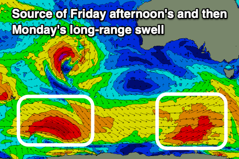
Now, into Tuesday, the first pulse of W’ly swell from an active storm track projecting towards but then breaking down once crossing Western Australia is due.
We’re set to see back to back strong storms moving through the Indian Ocean, a low latitudes, generating back to back pulses of W’ly swell, moderate to large through the middle of the week.
The first swell will be generated by a tight system moving in towards WA Friday and Saturday, with a moderate + sized, mid-period W’ly pulse due to 2ft+ on the Mid Coast with the South Coast not seeing much size over 3ft across Middleton.

A secondary stronger system looks to generate a stronger groundswell for later Tuesday but more so Wednesday, coming in at possibly 3ft+ the gulf, while Middleton comes in at a slower 4-5ft.
Winds through this run of swell will be mostly out of the north, favouring the South Coast, with the Mid being bumpy thanks to NE tending N/NW breezes. They won’t be too strong to adversely affect things Tuesday, stronger N/NE to N/NW Wednesday, adding lots of chops.
A brief W/SW change is expected on Thursday as one of the mid-latitude system clips us, with winds swinging back N/NW Friday along with plenty more swell. More on this Friday though.

