Secondary good S'ly swell tomorrow but with average conditions
South Australian Forecast by Craig Brokensha (issued Friday May 17th)
Best Days: This morning ahead of the change, dawn Sunday for those in the area down South, Tuesday/Wednesday/Thursday mornings down South
Features of the Forecast (tl;dr)
- Moderate + sized S/SW groundswell tomorrow AM with lumpy conditions under an E/NE breeze, tending SE later
- Smaller Sun AM with increasing S/SW winds, likely variable at dawn
- Moderate sized mid-period S/SW swell late Sun but more so Mon AM with fresh S winds
- Easing swell Tue with E/NE tending S/SE winds
- Inconsistent S'ly groundswell Wed AM with E/NE-NE tending S/SE winds
- Smaller Thu with NE tending SE winds
Recap
Our strong pulse of S/SW groundswell for yesterday filled in nicely with a peak seen during the afternoon to 4-5ft across the South Coast with offshore tending variable winds, while the Mid Coast pulsed to 1.5ft+.
This morning the swell was still in the water across both regions, coming in at 4ft down South and 1.5ft+ on the Mid Coast with clean conditions. Make the most of it before a trough brings freshening S/SE winds.

Nice sets hanging in the gulf this AM
This weekend and next week (Apr 18 - 24)
Following a couple of days of great surf, we’ve got a run of tricky conditions and onshore winds as we fall on the backside of all this current frontal activity and high pressure sits to our west.

A change this afternoon will be linked with our secondary, strong swell producer for tomorrow morning clipping the state.
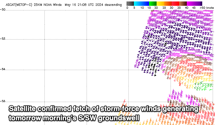
A great fetch of severe-gale to storm-force W/SW winds have generated another strong pulse of swell for early tomorrow, though the late intensification in our swell window will limit it getting too big.
Another kick to the 4-5ft range is due across the South Coast while the Mid Coast won’t be as favourable and likely a slower 1ft with the odd possible 1.5ft’er in the mix.
Today’s trough will clear allowing winds to swing E/NE across the South Coast tomorrow morning but there’ll likely be a lot of lump. Sea breezes look relatively weak so later morning might be the best chances to surf.
Sunday is a tricky one, with another trough likely to bring S/SW winds from around dawn, but we may see early variable W/NW breezes. Don’t count on it though. Swell wise the S/SW energy looks to be back to the 3ft range.
Unfortunately a more embedded S’ly flow is due into Monday as the high sits just west of us, and another swell producing front skirts its southern flank on the weekend.
We should see the moderate sized, mid-period energy from this frontal system, reaching 3ft+ across Middleton later in the day Sunday but more so Monday, tiny on the Mid Coast.
More variable E/NE-NE winds may be seen on Tuesday morning, similar Wednesday along with an inconsistent S/SW groundswell.
The source will be a strong polar low on the polar shelf, but it’ll be cut in half by the ice shelf, and won’t come in as good as it looks on paper. A slim fetch of severe-gale to storm-force W’ly winds should still generate a spike on dark Tuesday but more so Wednesday morning to 3ft across Middleton, easing through the day and smaller Thursday.
Longer term next weekend looks cleaner for the beaches with small, background swells, followed by some better swell for the following week. More on this Monday. Have a great weekend!


Comments
Cameras down south need to be cleaned, please.
Agree Seabiped. I guess we should be grateful people are willing to run them but the bay is the only one you can see. Been that way for months. Onshore don't help.
Heard they are upgrading to self cleaning camera's soon