Fun weekend for the Mid, better down South early next week
South Australian Surf Forecast by Craig Brokensha (issued Friday March 1st)
Best Days: Mid Coast today, tomorrow, Sunday and Monday for the keen, South Coast for the keen and experienced Monday morning but more so Tuesday morning
Features of the Forecast (tl;dr)
- Moderate sized W/SW-SW swell filling in today
- Stronger moderate-large sized W/SW-SW swell for tomorrow with mod-fresh E/SE-SE tending S/SE winds
- Reinforcing, more consistent moderate-large sized W/SW-SW swell Sun with fresh S/SE-SE winds
- Large S groundswell Mon with E/NE tending SE winds, easing Tue with N/NE morning winds
- New W/SW swells later next week
Recap
The surf was small but clean down South yesterday morning, with a tiny 1-1.5ft wave on the Mid Coast for the keen under generally favourable winds.
Into today, our first pulse of mid-period W/SW-SW swell has filled in, offering clean, inconsistent 1-2ft sets on the Mid Coast magnets and clean 2-3ft surf down South. Sea breezes will kick in across both coasts this afternoon, creating deteriorating conditions.

Little waves on offer today
This weekend and next week (Mar 2 - 8)
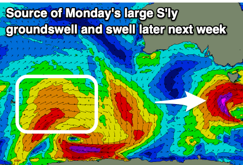
Today's swell is due to be boosted by a stronger pulse of groundswell energy tomorrow, offering more consistent 1-2ft waves across the Mid Coast and 4-5ft+ sets down South. The source of the swell was the backside of a strong polar low that fired up to the south-west of Western Australia.
This has then been followed by a healthy, broad frontal system moving under the country, with it currently sitting south of us. A good pulse of reinforcing mid-period SW swell will be added to the mix later tomorrow and more so Sunday morning, coming in at the 2ft range across the Mid Coast and 4-6ft across the Middleton stretch.
Looking at the local winds and the Mid Coast will be the pick for the most part with E/SE-SE winds tomorrow morning, S/SE-SE on Sunday.
For South Coast surfers, tomorrow morning looks the cleanest of the weekend.

Now, moving into next week, one final pulse of large S'ly groundswell is due across the South Coast Monday, linked to a final, strong low firing up on the tail of the current frontal activity, with it forecast to generate a fetch of severe-gale to possibly storm-force SW winds while racing through our southern swell window tomorrow and Sunday morning.
This low will generate the largest of the swell pulses this coming period, with a strong kick in size due Monday morning to 6ft+, tiny on the Mid Coast with easing 1-1.5ft sets from Sunday.
Winds should start improving, swinging E/NE Monday morning but there'll be a lot of leftover wobble and lump from Sunday's winds, better Tuesday with a N/NE offshore and steadily easing sets from 3ft to possibly 4ft.
Wednesday will be smaller with what looks to be variable winds ahead of an afternoon S/SW change.
Longer term, a healthy frontal progression is due to fire up south-west of Western Australia early-mid next week. This should produce some fun W/SW swell for later in the week with winds that look most favourable for the gulf (small in size). More on this Monday though. Have a great weekend!


Comments
Nice to see the southeren ocean looking more favourable...hope it continues.