Fun waves on the magnets for the coming days, bigger on the weekend
South Australian Surf Forecast by Craig Brokensha (issued Monday 26th)
Best Days: South Coast tomorrow morning, Wednesday and Thursday morning, Mid Coast for the keen Friday but more so Saturday, South Coast early-mid next week
Features of the Forecast (tl;dr)
- Small, mid-period SW Tue and Wed
- N/NE tending SE winds Tue, fresh N/NW-NW tending W/NW Wed
- Small surf continuing Thu with W/NW tending SW winds
- Moderate sized W/SW-SW swell filling in Fri with SE winds ahead of sea breezes
- Stronger moderate sized W/SW-SW swell for Sat with mod-fresh S/SE winds
- Easing swell Sun with fresh E/SE-SE tending S/SE winds
- Possible large S/SW groundswell Mon with E/NE tending SE winds, easing Tue with N/NE morning winds
Recap
Friday afternoon's good pulse of swell across the Mid Coast cleaned up into Saturday morning but eased in size and consistency as the direction shifted more south. The surf was mostly 1-1.5ft with the rare bigger one, not helped by the early high tide, easing through the day. The South Coast was large and onshore, great yesterday with clean morning conditions and plenty of size still left in the 3-4ft range.
From later morning yesterday, a fresh onshore change spoilt conditions with this morning coming in small and sloppy.

Chunky, clean surf yesterday AM
This week and weekend (Feb 27 – Mar 3)
The coming days look better for surf across the South Coast but mostly the magnets with Middleton being ideal for beginners.
Background levels of mid-period SW swell should come in at 2ft+ tomorrow and Wednesday morning with a N/NE offshore tomorrow morning ahead of relatively weak sea breezes, N/NW-NW on Wednesday morning, shifting W/NW through the day.
This change in the wind will be ahead of a weakening mid-latitude low moving in from the west, attached to a stronger frontal progression that's currently firing up to the south-west of Western Australia.
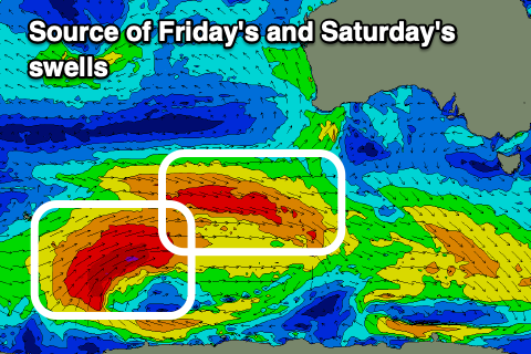
This progression will move through a mix of our south-western and western swell windows, with an initial frontal system due to generate a fetch of weak W/SW winds through the Mid's swell window today, producing a tiny swell for Thursday.
Behind this though, a stronger polar low is generating a fetch of W'ly gales, followed by stronger gale to severe-gale W/SW winds.
This will generate a moderate sized pulse of W/SW-SW swell for Friday followed by a stronger groundswell Saturday.
A third final pulse of SW swell may be seen into Monday but we'll review this in Wednesday's update.

Friday's pulse should build to 1-1.5ft on the Mid Coast and 3ft+ across Middleton with Saturday coming in at 1-2ft and 4-5ft+ respectively in the gulf and down South.
Local winds however only look to favour the Mid Coast unfortunately as a high moves in behind a SW change Thursday's, swinging back to the SE Friday morning (only light down South), with Saturday seeing fresher S/SE winds.
We'll see winds slowly swing SE into Sunday morning and then E/NE Monday morning as the high moves further east, and this will slowly improve the South Coast though it looks best from Tuesday with a more convincing N/NE offshore.
The models are still divergent on a tight but very strong low firing up on the backside of the progression, south of the country on the weekend, bringing a large reinforcing S/SW groundswell for Monday so we'll review this on Wednesday.

