Large swell for this afternoon and tomorrow with an improvement in the winds
South Australian Surf Forecast by Craig Brokensha (issued Friday 23rd)
Best Days: Mid Coast this afternoon, both coasts tomorrow, South Coast Sunday morning, South Coast Tuesday morning and Wednesday
Features of the Forecast (tl;dr)
- Large, reinforcing S'ly groundswell tomorrow with E winds on the Mid, E/NE down South ahead of sea breezes
- Rapidly easing S swell Sun with N/NW winds ahead of a weak S'ly change mid-late AM, fresher late
- Fresh SE tending S/SE winds Mon with a small, mid-period SW swell building, holding Tue and Wed
- N/NE tending SE winds Tue, stronger N/NE tending N/NW Wed
- Stronger swells later next week and into the weekend
Recap
Yesterday morning started clean and glassy down South with a tiny leftover swell, best across the magnets before an onshore change moved through.
Today the surf was started small, weak and onshore but a strong pulse of SW groundswell is on the build, with a sharp J-curve showing on the Cape du Couedic wave height recordings, but the large gap between the peak periods (15-6s) and average period (10s) show's there's a lot of windswell contamination in those readings.
Regardless we're on target for the Mid Coast to reach 2ft+ this afternoon and 6ft on the sets across Middleton but with those onshore winds.

This weekend and week (Feb 24 – Mar 1)
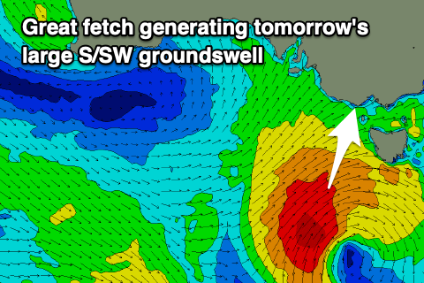
This afternoon's large pulse of SW groundswell energy was generated by the most intense stages of a significant low that formed south of the Bight mid-week. The low has since weakened but is generating a fetch strong to gale-force SW winds in our southern swell window, generating a large, reinforcing pulse of S/SW-S'ly swell tomorrow.

This now looks to maintain 5-6ft sets across Middleton tomorrow, easing later and then down from 3ft+ Sunday morning. The Mid Coast should fade back quickly from 1-2ft tomorrow, tiny and 0.5-1ft or so Sunday.
Winds are still best for the Mid Coast tomorrow but the South Coast is now looking cleaner with a light E/NE breeze due ahead of fresh S/SE sea breezes, great Sunday with a light N/NW offshore, with the S'ly change now pushed more towards mid-late morning. It'll only be weak initially anyway before freshening into the evening.
SE winds look to persist into Monday morning along with smaller surf, but a small, reinforcing SW swell is due through the day, generated by a weak polar frontal system that developed south-west of Western Australia the last couple of days.
Inconsistent 2ft+ sets are due across Middleton, tiny on the Mid Coast but with N/NE winds Tuesday morning, it'll be worth a sniff across the magnets. Wednesday looks similar in size and with strengthening N/NE tending N/NW winds ahead of a late change.
As touched on in Wednesday's update, the longer term outlook is very active with the Southern Ocean storm track due to fire up through next week and into next weekend, bringing a moderate to large run of swell with what looks to be S'ly winds. More on this Monday. Have a great weekend!

