Fun surf tomorrow with a workable weekend
South Australian Surf Forecast by Craig Brokensha (issued Wednesday 14th)
Best Days: Both coasts tomorrow morning, South Coast Friday morning, Saturday morning and early Sunday, South Coast Monday morning
Features of the Forecast (tl;dr)
- Inconsistent, moderate sized mid-period SW swell tomorrow, easing Fri
- Moderate E/NE tending S/SE winds tomorrow down South, E/SE tending S/SW on the Mid
- E-E/NE winds down South Fri ahead of S/SE sea breezes
- Reinforcing mid-period SW swells both Sat and Sun with variable offshore tending S/SE winds Sat, variable early Sun ahead of a S'ly shift mid-AM
- New small-mod sized mid-period SW swell for Mon PM, easing Tue
- Variable winds Mon AM, light S Tue AM
Recap
Yesterday's window of clean conditions was small, with an onshore change kicking in around 8am, spoiling the surf for the rest of the day down South, while kicking up some weak windswell on the Mid Coast.
Today conditions are poor with a bit more size down South, lumpy and windswelly to 1ft in the gulf. Some stronger swell should reach 1-1.5ft during the day across the Mid Coast as winds go more south and freshen, cleaning up later.
This week and weekend (Feb 15 - 23)
This morning's kick in size across both regions is linked to the frontal system bringing yesterday morning's change and with it some low period swell energy.
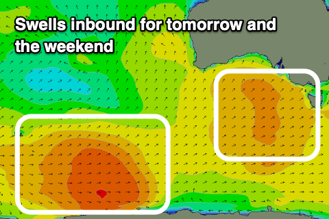
Stronger levels of mid-period SW swell are due to fill in later today but more so tomorrow, generated by the earlier stages of the frontal system on the polar shelf.
This should provide inconsistent 3-4ft sets across the Middleton stretch with 1-1.5ft sets on the Mid Coast along with more favourable conditions.

Winds look good for both regions tomorrow though not true offshore down South, with a moderate E/NE breeze due to create wobbly/lumpy surf (still worth a paddle), with E/SE offshores on the Mid Coast.
The swell will ease into Friday from 1ft and 3ft respectively on the Mid and around Middleton with what looks to be similar, light E to possibly E/NE winds down South in the morning, offshore in the gulf ahead of sea breezes.
The start of the weekend is still looking cleaner down South with some fun pulses of background swell.
The first will be mid-period energy, generated by a weak front passing under us tomorrow, maintaining 2-3ft sets across Middleton Saturday, while a stronger but inconsistent groundswell is due later in the day, peaking Sunday. This was generated by a strong but short-lived polar low in the Heard Island region and should maintain those 2-3ft sets into Sunday, easing later in the day.
On Saturday a light, local offshore wind is due down South ahead of S/SE sea breezes, with Sunday seeing a less reliable window of early variable winds, tending S/SE through the morning. We'll confirm this Friday.
Into next week, a small to moderate sized pulse of mid-period SW swell is due from a strengthening frontal system under us Saturday, with another fun kick back to 2-3ft due into Monday afternoon, easing Tuesday from a similar size.
Winds look favourable and variable Monday morning, possibly a little dicey on Tuesday but we'll take another look at this Friday. Beyond this there's nothing major due until late next week/weekend and with dicey winds.

