Improvement in wind outlook for the weekend down South
South Australian Surf Forecast by Craig Brokensha (issued Friday January 26th)
Best Days: Mid Coast tomorrow, South Coast early tomorrow, both coasts Sunday morning, South Coast Monday morning, Mid Coast late Wednesday and Thursday
Features of the Forecast (tl;dr)
- Moderate sized mix of mid-period W/SW swell and groundswell building this afternoon, peaking tomorrow, easing slowly Sun
- Light W/NW winds early down South tomorrow, shifting S/SW mid-AM and freshening
- E/SE tending fresh SW winds on the Mid tomorrow
- Variable offshore winds Sun AM ahead of sea breezes, similar Mon ahead of a shallow S'ly change late-AM
- Gusty S/SE-SE winds Tue through Thu with a small, fun W/SW swell for Wed PM and Thu
Recap
Nothing of note yesterday with light winds and a small to tiny swell across the South Coast, tiny inside the gulf.
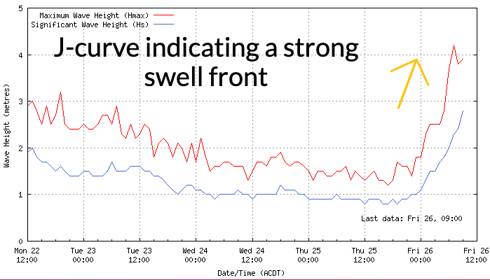
Today we've got a cooler, onshore change and a building mix of W/SW swells, with the mid-period and groundswell energy just starting to hit the Cape du Couedic wave buoy, producing a strong J-curve. Expect the Mid Coast to reach 2ft+ this afternoon but with strong SW winds, only tending S/SE after dark.
This weekend and next week (Jan 27 – Feb 2)
The weekend ahead looks great for surf with this afternoon's mix of W/SW swells due to peak through tomorrow morning.

The source was a strong frontal system that projected towards and then under Western Australia, with it weakening while clipping the state today, bringing the cooler SW winds.
A mix of groundswell and mid-period energy will be in the water this afternoon and tomorrow, with a peak due tomorrow morning to 4ft across Middleton, with 2-3ft sets across the Mid Coast all day.
The easing trend should be slow with 1-2ft sets in the gulf Sunday, still 3ft+ most of the day down South before easing back from 1ft and 2ft+ respectively on the Mid and down South Monday.
Winds are now looking better for the South Coast tomorrow with a local offshore W/NW breeze due, shifting fresh SW-S/SW mid-morning so go the early. The Mid Coast should see morning E/SE offshores ahead of fresh sea breezes, though not enough to stop a session into the afternoon.
Into Sunday variable winds are due, tending light NE down South and E on the Mid Coast ahead of sea breezes, similar Monday morning though a trough is due to bring a shallow S'ly change late morning, freshening into the afternoon.
Following Monday's change, persistent S/SE-SE winds are due to set in across the South Coast, creating average conditions with some weak localised windswell, while the Mid Coast should see some inconsistent W/SW swell energy Wednesday and Thursday, thanks to a broad but relatively weak frontal progression passing under Western Australia Sunday and Monday.
The best pulse of energy is due later Wednesday and Thursday with inconsistent 1-2ft sets likely on the Mid Coast but we'll confirm this Monday. In the meantime make the most of the coming swell and have a great weekend!

