Fun weekend on the Mid, larger down South next week but onshore
South Australian Surf Forecast by Craig Brokensha (issued Friday November 10th)
Best Days: This morning South Coast, Mid Coast later tomorrow and Sunday, Mid Coast for the keen Monday through Wednesday (tiny)
Features of the Forecast (tl;dr)
- Small Sat with strengthening S/SW-S/SE winds (S/SE-S on the Mid)
- Moderate sized, inconsistent W/SW-SW swell arriving later Sat, peaking Sun AM with moderate S/SE-SE winds, strengthening from the S/SE into the PM
- Temp drop in size Mon AM, ahead of a new mid-period S/SW swell into the PM with E tending S/SE winds
- Moderate sized S/SW for Tue with mod S/SE winds, freshening
- Larger S/SW groundswell Wed with fresh S winds, strengthening
- Easing surf Thu with fresh S-S/SW winds
- Smaller Fri with S winds
Recap
A light SE breeze created workable waves across the South Coast yesterday morning with a slow but good 2-3ft of swell across Middleton/Goolwa, tiny and to 0.5ft max on the Mid Coast.
This morning the swell is easing from 2ft but with cleaner conditions, best across the regional magnets and tiny on the Mid Coast.

Fun surf this morning
This weekend and next week (Nov 11 - 17)
Early this evening, a strong SW change is due as a cold front pushes in from the west, clipping the state. This will leave strong S/SW tending S/SE winds on the South Coast tomorrow with small surf, while S/SE-S winds are due across the Mid Coast all day, tiny in the morning though building into the afternoon as a new W/SW swell arrives.
The source of this swell was a broad, slow moving polar low that formed to the south-west of Western Australia is is now weakening south of that state today.
A late pulse to 1-2ft is due in the gulf, peaking Sunday to 2ft while the South Coast should provide 3-4ft sets across Middleton on Sunday morning as it peaks.
Winds will be S/SE-SE across the gulf on Sunday morning, freshening from the S/SE through the afternoon.
Winds look to ease and shift E'ly into Monday morning down South, but conditions will still be lumpy and all over the place due to the weekend's onshore blow. The Mid Coast looks to ease back from 1-1.5ft.
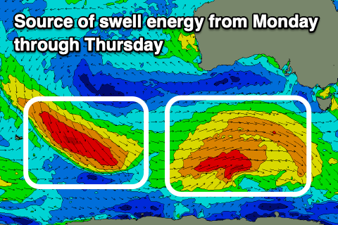
Looking closer at the South Coast, and building levels of moderate sized mid-period S/SW swell are due into Monday afternoon but more so Tuesday, followed by a stronger S/SW groundswell Wednesday.

These swells will be generated by back to back storms firing up under the country on the weekend, with an initial polar low due to generate a good fetch of strong to near gale-force W/SW winds, followed by a stronger fetch of W/NW tending W/SW gales.
The first low should produce a moderate sized S/SW swell to 4-5ft across Middleton Tuesday, 1-1.5ft on the Mid Coast, while the stronger groundswell looks to come in at 4-6ft Wednesday.
Winds won't be great Tuesday and moderate from the S/SE-SE down South, clean across the Mid Coast ahead of W/SW-SW sea breezes.
Winds will unfortunately revert back to the S'th and freshen on Wednesday, creating poor conditions down South (S/SE on the Mid Coast), persisting from the S'th on Thursday.
The reason for this run of poor winds is a strong high setting up camp under Western Australia as we fall under the influence of its eastern flank, squeezed by troughs and fronts pushing up, under Tasmania.
A temporary break in the pattern is likely next weekend but with small, leftover swells. More on this Monday. Have a great weekend!

