Windy, poor surf to come, improving late week
South Australian Surf Forecast by Craig Brokensha (issued Monday October 23rd)
Best Days: Late today South Coast, Friday morning South Coast, Saturday South Coast
Features of the Forecast (tl;dr)
- Strengthening W/NW-W winds with building windswell across both coasts
- Easing swell across the Mid Coast with a mod-large S swell for the South Coast Wed with strong W/SW-SW tending S/SW winds
- Moderate sized + S swell Thu with gusty SE tending S/SE winds (possibly lighter E/SE for a period in the AM)
- Moderate sized mid-period S swell arriving Fri with NE tending E/SE-SE winds
- Easing S swell Sat with N/NE tending N/NW winds
Recap
Poor conditions Saturday across all locations with gusty onshore winds and choppy building surf across both regions, solid yesterday down South but still poor and onshore. The Mid Coast dropped back in size rapidly as the low linked to the wind aimed S'ly winds into the state.
This morning conditions are better though a little lumpy with easing 3-4ft sets across Middleton, tiny and bumpy across the Mid Coast. Expect the swell to continue easing into the afternoon along with funky winds. An approaching trough looks to bring a brief E/SE sea breeze, tending variable later afternoon and evening. One worth keeping an eye on.
This week and weekend (Oct 21 - 27)
Tomorrow will be a lay day as the approaching trough brings strong W/NW-W winds along with a low point in S'ly swell in the morning ahead of building windswell through the day.
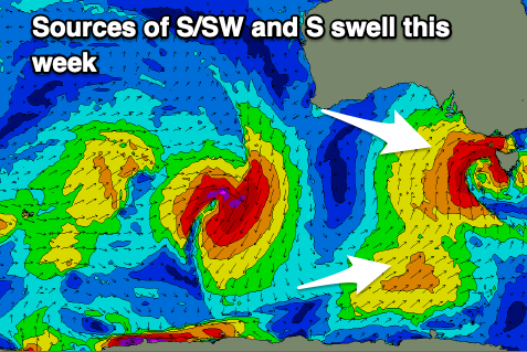
The trough is actually forecast to develop into a low while moving south of us and this will aim a fetch of strong to gale-force S/SW winds into the South Coast through the day.
This will generate a moderate-large spike of S'ly swell for Wednesday morning, coming in at 4-6ft across Middleton but with strong W/SW-SW winds that will shift more S/SW through the afternoon. The Mid Coast looks to be 2ft+ but a mess.

Moving into Thursday the low will start moving to the east, but a broad fetch of S'ly winds aimed into the South Coast will maintain poor quality 3-5ft surf, while a secondary polar front projecting slightly stronger winds in our southern swell window will produce a reinforcing S'ly swell for Friday, arriving mid-late afternoon.
A kick to a good 4ft is due (possibly a little undersized early), easing Saturday from 2-3ft. The Mid Coast will fade through Thursday, likely 1-1.5ft max and tiny into the end of the week.
Now, winds on Thursday will remain poor and fresh from the SE across the South Coast, possibly tipping E/SE for a period, with Friday looking more favourable under a NE offshore ahead of SE sea breezes.
Saturday will be great with N/NE tending N/NW winds, but small to tiny surf into the afternoon.
Besides some tiny pulses of background W/SW swell for the weekend, the next considerable increase in size looks to arrive from the SW, generated by a broad Southern Ocean frontal progression firing up on the weekend. Unfortunately it looks to arrive with S/SW winds Tuesday, S/SE on Wednesday. The Mid looks to be the pick with smaller but fun surf. More on this Wednesday.

