Tricky period of winds and funky swells
South Australian Surf Forecast by Craig Brokensha (issued Friday October 20th)
Best Days: Today South Coast, Monday morning South Coast, Friday morning South Coast
Features of the Forecast (tl;dr)
- Small to tiny tomorrow morning with building windswell through the day under strong W/SW tending SW winds
- Large mid-period S'ly swell for Sun AM, easing into the PM and further Mon
- Strong S/SW-SW winds Sun, easing through the day
- Variable N/NE winds Mon AM ahead of S/SE sea breezes
- Tiny Tue with W/NW tending strong W/SW winds
- Mod-large S swell Wed with strong S/SW-SW winds
- Easing swell Thu with S/SE winds
- Possible moderate sized S swell Fri with gusty NE winds
Recap
The South Coast has offered fun waves the last two days thanks to offshore winds and a new S/SW groundswell yesterday that provided inconsistent but good 3ft sets, smaller and easing from 2ft today.
The Mid Coast was tiny and to 0.5-1ft yesterday with glassy conditions, tiny and wind affected today.

Slow but fun sets when they came yesterday
This weekend and next week (Oct 21 - 27)
I hope you've made the most of the last couple of days as the coming period is very fluky.
We'll see deepening troughs and mid-latitude lows moving in from the west, bringing with it poor winds and building low quality swells that will get quite sizey across the South Coast. The only issue is that once the swell generating systems start moving east and clearing, the swell will back off rapidly with offshore winds due to kick in properly once it's small to tiny.
So, the first of these systems is expected to move in this evening bringing strengthening W/NW winds that will then tend W/SW tomorrow morning and SW through the afternoon as a low forms south of us, stalling through the day.

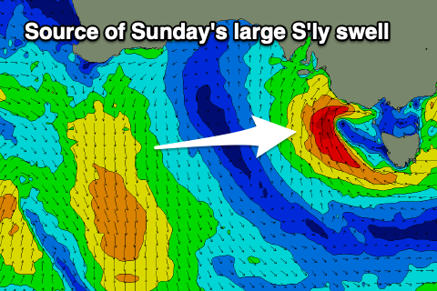
This will kick up building levels of windswell across both the Mid Coast and South Coast, with some stronger mid-period S'ly energy due on Sunday thanks to better strength S'ly winds forming south of us tomorrow afternoon and evening.
Tomorrow looks to start weak and cross-shore on the South Coast, while Sunday looks to come in at 6ft or so but with strong S/SW-SW winds that will slowly ease through the day.
The Mid Coast only looks to build to 1-2ft or so tomorrow, fading Sunday.
The low will move east into Monday, allowing winds to tend variable and even light N/NE along with lumpy, easing 3ft to possibly 4ft sets. This actually looks like a window worth targeting as Tuesday will be small to tiny along with early W/NW tending strong W/SW-SW winds as the next trough approaches.
This next trough will have a polar front attached to it, bringing a meridional (south-north) aligned fetch of strong S'ly winds through our swell window.
The models diverge on wether a low will form in the trough, bringing a larger pulse of S/SW swell through the middle of next week, but regardless strong S/SW-SW winds on Wednesday will shift S/SE on Thursday, spoiling the swell on the South Coast. The Mid will become cleaner but with fading 1-1.5ft sets.
Friday may see winds go NE down South and the swell may still be moderate in size. We'll have to review this on Monday though as the models diverge on the strength of the polar, swell generating system. Have a great weekend!

