Make the most of today and tomorrow
South Australian Surf Forecast by Craig Brokensha (issued Friday September 29th)
Best Days: Today both coasts, tomorrow South Coast, Monday for the desperate South Coast magnets, Wednesday for the keen on the Mid, Mid Coast Friday
Features of the Forecast (tl;dr)
- Gusty N/NW winds tomorrow with easing SW surf (NE at dawn on the Mid)
- Fresh but easing SW tending S winds Sun with small surf
- Small, weak swell Mon with N/NE winds
- Moderate sized W/SW swell for Tue with strengthening W/NW-W winds
- Larger W/SW groundswell building Wed (peaking later) with fresh S/SW winds, easing slowly Thu with gusty SW winds
- Large S/SW groundswell Fri with S/SE winds
Recap
Lighter winds and cleaner conditions were seen across both regions yesterday with small 2ft waves across Middleton and 1ft+ on the Mid Coast. A new pulse of W/SW swell energy started to show into the afternoon with weak sea breezes on the Mid Coast, bumpy down South, with a peak this morning to a great 3-4ft across Middleton and 1.5ft to occasionally 2ft on the Mid Coast. Early glassy conditions are now bumpy with a freshening N'ly wind, best down South.

South Coast lines
This weekend and next week (Sep 30 – Oct 6)
Our inconsistent W/SW groundswell has peaked and we'll see it easing slowly over the coming days and winds will favour the South Coast again tomorrow, fresh from the N/NW ahead of a front and SW change early Sunday morning.
The front will be weak and break down quickly on Sunday resulting in easing SW winds through the morning, tending moderate S-S/SE through the afternoon.
Size wise Middleton should ease back from the 3ft range tomorrow, 2ft on Sunday with easing 1-1.5ft sets across the Mid Coast tomorrow. A dawn NE breeze will provide OK but not great conditions tomorrow in the gulf before becoming choppy.
Into Monday winds will tend N/NE-N/NW but with weak 1-2ft sets max across Middleton, tiny on the Mid Coast.

Come Tuesday the first pulse of W/SW energy linked to a strong, slow moving Southern Ocean frontal progression firing up to the south-west of Western Australia will fill in.
This will be generated by strong W/NW winds, with the Mid Coast coming in at 1-1.5ft but with strengthening W/NW-W winds. The South Coast isn't due to offer much size with slow 2ft sets across Middleton.
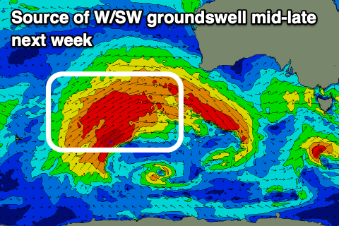
Of greater significance is the moderate to large W/SW groundswell generated by the progression proper, with a fetch of gale to severe-gale W/SW winds due to be projected through our medium-range swell window this weekend, weakening while moving under Western Australia early next week.
The groundswell should build Wednesday and peak later afternoon with the Mid Coast pulsing to an easy 3ft with 4ft sets likely on the magnets, easing back from 3ft on Thursday.

The South Coast looks to reach 4-6ft across Middleton later Wednesday, easing back slowly from 4-5ft on Thursday.
Unfortunately the remnants of the progression will move through bringing fresh S/SW winds on Wednesday, while a trailing front will bring gusty SW winds Thursday. All in all not ideal.
We're looking at a larger S/SW groundswell for Friday produced by a significant polar frontal progression early next week to the south of Western Australia but winds will remain out of the S/SE (creating cleaner options on the Mid but with the easing W/SW energy). More on this Monday. Have a great weekend!

