Improving surf later week
South Australian Surf Forecast by Craig Brokensha (issued Monday September 25th)
Best Days: Friday South Coast (early on the Mid), Saturday South Coast,
Features of the Forecast (tl;dr)
- Small, inconsistent W/SW groundswell this afternoon and tomorrow, easing Wednesday
- E/NE tending S/SE winds tomorrow, fresh S Wed
- Low point in swell Thu AM, with a new, moderate sized W/SW groundswell building into the PM, peaking Fri AM
- Local offshore winds Thu AM ahead of sea breezes
- N/NW winds Fri, freshening before shifting W/NW and easing
- N/NW winds Sat with easing SW surf
- SW change moving through Sun
Recap
The great swell seen late last week faded further into the weekend across both the Mid and South Coasts with tiny 1-1.5ft waves in the gulf Saturday, back to 0.5-1ft on Sunday. The South Coast was best on the magnets Saturday, tiny yesterday.
Today a trough has brought an onshore change for the South Coast with tiny, bumpy waves across the Mid Coast.
This week and weekend (Sep 26 – Oct 1)
It’s great to be back in the saddle after a couple of weeks offline, and looking at the week ahead, we've got a funky couple of days of winds before conditions improve into the end of the week along with a fun new swell.
Inconsistent, background swell energy is expected to pad out tomorrow with 2ft+ sets across Middleton and 0.5-1ft sets across the Mid Coast, easing back through Wednesday.
Winds are due to improve through tomorrow as today's trough pushes east, allowing cross-offshore E/NE-NE winds to kick back in across the South Coast, E'ly on the Mid ahead of afternoon sea breezes.
Wednesday looks average as another trough moves in through tomorrow evening, leaving fresh S'ly winds across both coasts mid-week.
Thursday morning will become cleaner with local offshore winds kicking back in though with a low point in swell.

Through the afternoon and more so Friday, some new swell is due to show, that being an inconsistent but moderate sized W/SW groundswell.
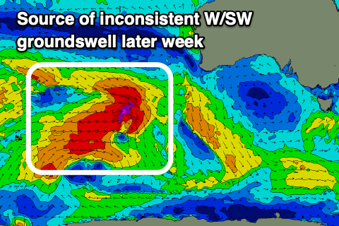
The source of the groundswell is a little distant to be ideal, though a good fetch of gale to severe-gale W/NW winds that are currently to the north-east of the Heard Island region, will track east-southeast today before breaking down this evening.
This should produce an inconsistent but fun sized W/SW groundswell that's due to build Thursday afternoon, reaching 3ft across Middleton and 1-1.5ft on the Mid Coast, with Friday morning seeing a peak to 3-4ft across Middleton as the Mid holds 1-1.5ft.
Winds look favourable again for the South Coast with a N/NW offshore due to freshen, weakening and shifting W/NW into the afternoon ahead of a weakening trough which looks to dissolve into Saturday, leaving persistent N-N/NW winds again across the South Coast as the swell eases from 3ft on the sets. The Mid will be best early Friday with a NE breeze, bumpy thereafter.
Longer term we've got some new W/SW swell energy due into next week though winds look to deteriorate for the Mid Coast. More on this in Wednesday's update.


Comments
Great to have you back!
Cheers!
Looks like the Mid had some pumping days.