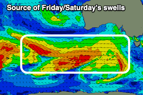
Increasing swell activity with varying winds
South Australian Surf Forecast by Craig Brokensha (issued Wednesday August 30th)
Best Days: Friday both coasts (Mid Coast for the keen), Saturday and Sunday South Coast, protected spots South Coast Monday/Tuesday/Wednesday morning
Features of the Forecast (tl;dr)
- Moderate sized + mid-period SW swell arriving late tomorrow with W/NW tending W/SW-SW winds mid-AM, peaking Fri with variable E/SE winds down South ahead of weak sea breezes
- Light E/SE winds ahead of weak sea breezes on the Mid Fri
- Slight drop in swell Sat with N/NE tending variable winds
- Smaller easing surf Sun with gusty N/NE-NE winds
- Mod-large W/SW groundswell building Mon with gusty NW-W/NW winds
- Large W/SW groundswell building Tue PM with strong W/NW winds
- Large S/SW swell Wed with strong NW tending W/SW winds
Recap
Small, clean surf yesterday morning across the South Coast, building a little into the afternoon but with strong, tricky offshore NW winds. The Mid Coast was tiny and became choppy through the day.
This morning there was a small window of light winds and cleanish conditions down South and 2-3ft sets across Middleton, now choppy with the change moving through proper. The Mid Coast is seeing a tiny windswell with moderate to fresh onshore winds.
This week and weekend (Aug 31 – Sep 3)
The cold front bringing today's change will be followed by a secondary stronger progression that's currently south of Western Australia, bringing W/NW winds tomorrow morning ahead of a shift back the W/SW mid-morning then SW through the day.

Building levels of mid-period W/SW swell are due into the afternoon, though a peak in size is due Friday from the SW, with a reinforcing slightly smaller pulse Saturday, easing through Sunday.
This swell is being generated by the frontal progression that's currently moving in from the west, generating a fetch of strong gale-force W'ly winds that will weaken while tracking east.
Middleton should come at 4ft+ Friday, easing back from 4ft on the sets Saturday morning and then 3ft Sunday morning on the sets. The Mid Coast should come in around 1.5ft, with the rare bigger one on the favourable parts of the tide as the swell peaks, tiny and easing through the weekend.
Winds on Friday still look a little dicey for the South Coast but fairly favourable with a variable E/SE breeze, ahead of weak sea breezes, with offshore tending weak onshore winds Friday.
The South Coast looks the pick on the weekend with a N/NE tending variable wind Saturday, fresh to strong N/NE-NE on Sunday. A shift in the weather and wind will be seen early next week as a strong mid-latitude low pushes in from the west, bringing strong NW winds, shifting W/NW into Tuesday.

The strong mid-latitude low will be the second in back to back, strong systems pushing up and under Western Australia from later this week, with the first generating a fetch of W/SW gales from the Heard Island region, with the second moving in on the back of the first, pushing in through the Bight Sunday/Monday.
Large, back to back pulses of W/SW groundswell are due, the first pulsing strongly Monday afternoon, with the second larger pulse for Tuesday afternoon, followed by a reinforcing S/SW swell for the South Coast Wednesday,
At this stage the Mid Coast looks to come in the 3-4ft range but onshore, with the South Coast offering surf to 4-6ft or so. We'll have a closer look at this and the local winds Friday.

