Make the most of this morning's conditions
South Australian Surf Forecast by Craig Brokensha (issued Friday August 25th)
Best Days: This morning South Coast, Mid Coast all day for those with lower expectations, Mid Coast for the depserate and beginners tomorrow, South Coast Monday morning and Tuesday
Features of the Forecast (tl;dr)
- Temp low point in swell Fri AM ahead of a moderate sized + pulse of SW groundswell, peaking Sat from the S/SW
- Light N/NW-NW winds down South Fri ahead of a freshening S change into the PM, N/NE early on the Mid, tending NW and then weak SW
- Fresh and gusty SE winds tomorrow, light-mod S/SE Sun
- Easing surf Mon with N/NE tending E winds
- New small S/SW swell building Tue, easing Wed
- Strengthening N/NW winds Tue, SW Wed
Recap
Wednesday's large pulse of SW groundswell came in right on cue with a the mid-late afternoon pulsing to 6-8ft on the deep water reefs around Victor under offshore winds. This swell was still strong but eased back through yesterday from 4-6ft, with this morning a little smaller but still stacked and to 3ft+ across Middleton.
The Mid Coast was clean at dawn yesterday and still 2ft+ but the wind quickly came up and got into it, similar today with 1-2ft leftovers. A trough will bring a shallow SW change on the Mid Coast this afternoon, fresher S'ly down South.
We should also see some moderate sized SW swell building but this is discussed in more detail below.

Racked and stacked this morning
This weekend and next week (Aug 26 – Sep 1)
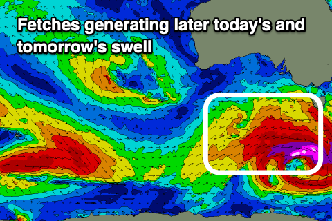
The second rapidly deepening low pressure system this week formed just south-west of us yesterday, dipping south-east with it now sitting under Tasmania. A pre-frontal fetch of gale to severe-gale W/NW winds in our south-western swell window are now being followed by similar strength W/SW winds on the edge of our southern swell window, producing a moderate sized SW tending S/SW swell for later today and more so tomorrow.
Middleton should kick to 4ft+ later today with 4-5ft sets tomorrow, easing back from 3-4ft on Sunday morning. The Mid Coast should persist in the 1-1.5ft range on the favourable parts of the tide tomorrow, easing Sunday.

Unfortunately winds will be poor in the wake of this afternoon's change and trough for the South Coast with gusty SE winds due tomorrow, clean on the Mid Coast.
Sunday looks a touch better but still average with a weaker, light to moderate S/SE breeze that will hold this strength most of the day. This is the day to target down South.
Moving into early next week the surf will continue to ease in size as winds improve for the South Coast. A light N/NE breeze is due Monday morning ahead of sea breezes and with easing 2ft to occasionally 3ft sets.
Tuesday will be clean all day with strengthening N/NW winds ahead of an approaching trough, and a small, new S/SW swell should build to 2ft to occasionally 3ft on the sets across Middleton into the afternoon. The source is a short-lived fetch of W/NW gales on the polar shelf, south-west of Western Australia today.
Similar sized surf is due Wednesday morning, then easing but with onshore, SW winds as the front clips us. No swell is due from this trough with small, background levels of energy due into Thursday.
We might see a slightly better W/SW swell for Friday with winds out of the north, generated by a frontal progression moving in from under Western Australia mid-week but check back here Monday for an update on this. Have a great weekend!


Comments
How good is friday looking. Correct me if I'm wrong Craig, but highs are less vulnerable to shifting around in the forecasts than other synoptic features right?
Yeah in general. Highs are much more stable and slower moving, with fronts and troughs butting in either side of them.
Cheers