Large swell on the way for the South Coast
South Australian Surf Forecast by Craig Brokensha (issued Wednesday August 23rd)
Best Days: Today both coasts (late on the Mid), early Mid Coast tomorrow, South Coast all day, both coasts Friday morning, Mid Coast for the keen/beginners Saturday, South Coast Tuesday morning
Features of the Forecast (tl;dr)
- Large, long-period SW groundswell building strongly this afternoon with late easing winds from the N/NW-NW
- Large, easing surf tomorrow with moderate N/NW winds down South, freshening, mod-fresh NE early on the Mid
- Temp low point in swell Fri AM ahead of a moderate sized + pulse of SW groundswell, peaking Sat from the S/SW
- Light N/NW-NW winds down South Fri ahead of a freshening S change into the PM, N/NE early on the Mid
- Fresh and gusty S/SE-SE winds Sat and Sun
- Easing surf Mon with E/NE tending SE winds
- New small S/SW groundswell Tue AM, easing with N/NE tending SE winds
Recap
The South Coast offered plenty of swell but average to poor conditions yesterday with a gusty onshore wind, sloppy on the Mid Coast through the morning but a little better into the afternoon.
This morning we've got clean conditions and surf to 4ft continuing across Middleton, bumpy and to 2ft on the Mid Coast. A large pulse of new SW groundswell is due to arrive into the afternoon, generated by a 'bombing low' but this is discussed in more detail below.
This week and weekend (Aug 24 – 27)

This afternoon's large pulse of SW groundswell has been brought forward a little thanks to the 'bombing low' generating a significant fetch of storm-force W/SW winds through our swell window Monday evening.
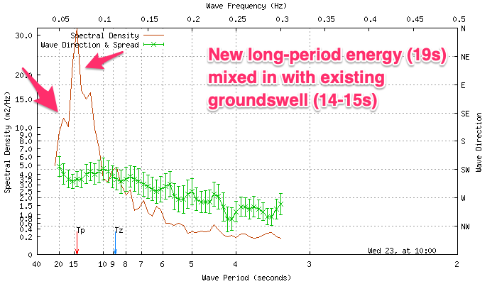
Satellite observations (left) of the low are impressive and with this we're now expected to see a large, strong swell front arriving earlier through the afternoon, likely now reaching 6ft+ across the South Coast by dark, maintaining 2ft+ sets on the Mid Coast, then easing back steadily through tomorrow from 5-6ft and 2ft respectively. The Cape du Couedic wave buoy (below left) has picked up this energy already so keep eyes peeled on the South Coast cams.
Locally winds look favourable with a fresh N/NW'ly on the Mid this afternoon due to back off later afternoon and into the evening, with lighter NW winds on the South Coast.

Tomorrow morning should be favourable for both regions with a moderate N/NW breeze down South, mod-fresh NE winds on the Mid (adding small bumps), with freshening N/NW winds into the afternoon.
Friday looks to play out similar with a light-moderate N/NE breeze on the Mid Coast though with smaller 1-1.5ft waves, N/NW-NW down South ahead of a trough which looks to bring a fresh S'ly change early afternoon.
We've got a reinforcing, moderate sized SW groundswell due to arrive later in the day but peak more so through Saturday, thanks to a rapidly deepening frontal progression to our southwest on tomorrow.
Fetches of gale to severe-gale W/NW-NW winds in our south-western swell window look to be followed by similar strength W/SW winds in our southern swell window, producing a moderate to large sized SW tending S/SW swell for later Friday and more so Saturday.

Middleton should pulse back to 4ft+ late Friday with Saturday seeing 3-5ft surf, easing back through Sunday from 3-4ft.
The Mid Coast isn't expected to see much size from this late forming progression, coming in at 1-1.5ft on the favourable parts of the tide.
Unfortunately in the wake of Friday's trough and change, a high will move in bringing fresh S/SE-SE winds on Saturday and Sunday, creating poor conditions down South.
A slow improvement in winds is due Monday with a light E/NE cross-offshore leaving plenty of lump down South. The Mid Coast will be tiny into Monday and the South Coast looks to ease back from 2ft to possibly 3ft.
Longer term, a fun S/SW groundswell is expected on Tuesday morning, generated by a great fetch of pre-frontal, gale to severe-gale polar W/NW winds. 2-3ft sets are due off Middleton with better N/NE offshore winds but we'll confirm this on Friday.
Beyond this the outlook is very spring like with a troughy weather pattern, varying winds and no significant swells. So make the most of the current and coming energy.

