Make the most of the coming days (apart from Tuesday) before winds go poor on the weekend
South Australian Surf Forecast by Craig Brokensha (issued Monday August 21st)
Best Days: Today South Coast, Wednesday, Thursday, Friday morning
Features of the Forecast (tl;dr)
- Mod-large mid-period W/SW swell building Tue ahead of a larger SW groundswell later Wed, easing Thu
- Mod-fresh SW-W/SW winds tomorrow
- Light to mod NW winds Wed, tending N/NW on the Mid in the PM
- Easing surf Thu with local offshore winds (NE early Mid), tending N/NW-NW through the day
- Smaller Fri AM with W/NW tending fresh S winds down South, NE tending S on the Mid
- Late pulse of SW swell Fri, peaking Sat with S winds
- Easing surf Sun with E/SE-SE winds
Recap
Winds backed off across the Mid Coast on Saturday leaving lumpy, bumpy 2ft+ waves for the keen, cleaner and hanging in at 1-2ft yesterday. The South Coast was best in protected spots and still solid, cleaner yesterday and back to the 3ft range.
Today a mix of reinforcing W/SW swells have filled in, but wind affected across the gulf and to 1-2ft, best down South and to 3-4ft off Middleton.

Clean and a good size this AM
This week and weekend (Aug 22 – 27)
Today's strengthening N/NW winds are ahead of a surface trough which is expected to bring a moderate to fresh SW change for tomorrow morning.
This will be as some stronger W/SW groundswell energy fills in, generated by a strong Southern Ocean frontal progression that fired up between Heard Island and Western Australia. A broad fetch of slow moving strong to gale-force W/SW winds were seen, with the swell due to build to 3ft across the Mid through the afternoon with Middleton building to 4-5ft but with those onshore winds.
Moving into Wednesday we're looking at cleaner conditions as winds shift NW down South, while remaining onshore from the NW across the Mid Coast but not to the strength of tomorrow. Lighter N/NW winds into the afternoon should create improving conditions across the gulf and swell wise, we'll have the W/SW energy from Tuesday along with an afternoon pulse of stronger W/SW-SW groundswell across the South Coast.
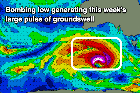
This will be produced by a 'bombing low' forming to the south-west of Western Australia today. That being a low dropping rapidly in surface pressure, at least 24hPa in 24 hours. We'll actually see this low drop 40hPa within 24 hours, from 979hPa early this morning to 939hPa tomorrow morning.
With such a rapid drop in central pressure, we'll see severe-gale to storm-force W/NW-W/SW winds winds forming around the core of the low as it tracks east-southeast through our swell window and broadens in scope.

The track and formation is a little late for the Mid Coast's swell window and late in the South Coast's swell window, but we should see a strong pulse of size into the mid-late afternoon, building to 6ft across Middleton and other deep water reefs, easing back from a similar size Thursday morning.
The Mid Coast looks to ease back from 2ft+ Thursday morning and local winds look great for the South Coast and workable for the Mid. A light N/NW breeze is due across Middleton, tending NW through the day, with NE tending N/NW winds on the Mid Coast.
Friday looks to play out similar with light, local offshore winds early, but a trough will bring a S'ly change mid-morning.
This will be with a further drop in size ahead of some possible new swell later in the day but more so Saturday.
The energy due on Saturday again will be generated late in our swell window with a strengthening frontal progression forming under us Thursday due to likely maintain 3-4ft waves across Middleton, with tiny waves on the Mid. S'ly winds will unfortunately persist across both regions Saturday, tending E/SE-SE into Sunday as a high moves east but we'll confirm this Monday.
The outlook into next week is a little dicey as another high looks to move in through Wednesday, following a trough. This will see winds cycle between S/SE-SE to E again with no major swell. Therefore make the most of the coming period of swell and favourable winds!

