Lots of swell to come with the South Coast being cleanest
South Australian Surf Forecast by Craig Brokensha (issued Wednesday August 16th)
Best Days: Tomorrow both coasts, protected spots down South Saturday, Sunday down South, Monday through Thursday down South, with possibly morning windows for the Mid Coast
Features of the Forecast (tl;dr)
- Late increase in inconsistent W/SW groundswell Wed, peaking Thu with light E/NE tending W/NW winds on the Mid, N/NW tending variable down South
- Easing swell Fri AM, with a building windswell for the PM
- Fresh to strong SW tending W/SW winds Fri
- Mod-large mix of SW swells Sat, easing and smaller Sun
- W/NW-W winds Sat, W/NW-NW Sun
- Moderate sized mid-period SW swell Mon with fresh N/NW tending NW winds
- Larger W/SW-SW groundswell building Tue PM, peaking Wed with NW winds
- Easing surf Thu with N/NE winds
Recap
Good clean conditions with easing sets from 2-3ft across the South Coast with clean 1ft+ waves on the Mid Coast, smaller this morning and back to 2ft down South with bumpy 1ft waves persisting on the Mid Coast.
This week and next (Aug 17 – 25)
Later today we may see long-range, inconsistent W/SW groundswell but tomorrow is when we'll see the swell peaking, generated in our far to medium-range swell window since late last week.
Infrequent 4ft sets are due across Middleton tomorrow with 2ft sets on the favourable parts of the tide across the Mid Coast, easing later and smaller into Friday.
As the swell eases though, some new mid-period W/SW swell should maintain 2ft waves on the Mid Coast thanks to a front pushing through tomorrow afternoon and evening.

Winds look favourable for both coasts tomorrow, though best early on the Mid with an E/NE tending W/NW breeze in the gulf and N/NW tending variable winds on the South Coast.
The front will unfortunately leave strong SW tending W/SW winds into Friday creating poor conditions, shifting W/NW-W on Saturday providing clean conditions in protected spots down South.
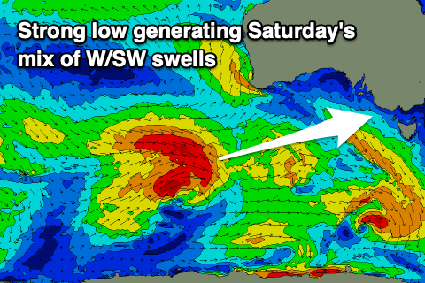
Moving into Saturday, our moderate-large mix of W/SW-SW swells is due to peak through the morning, with it possibly showing up on dark Friday.
The source of this swell is a low that formed east of the Heard Island region yesterday evening.
The low will generate a persistent fetch of gales, weakening temporarily south of Western Australia today before strengthening again slightly south of the Bight, though being tighter and smaller in nature.
This looks to result in a mix of mid-period and groundswell energy for Saturday, peaking to 4-6ft across Middleton and 2ft to occasionally 3ft on the favourable parts of the tide across the Mid Coast.

The swell is due to ease through the afternoon, dropping further from 4ft off Middleton and 2ft across the Mid Coast Sunday.
W/NW-NW winds look to persist Sunday, possibly variable for a period early on the Mid Coast, though we'll confirm this on Friday.
Moving into next week and we've got a stronger, broader and more prolonged Southern Ocean frontal progression expected to form around the Heard Island region late week, pushing slowly east on the weekend and then under the country early next week.
We're looking at a large mix of SW groundswells into Wednesday, with an initial pulse Tuesday from pre-frontal activity. Winds look to be out of the north-western quadrant for the most part and possibly N/NE Thursday as the swell eases but check back here on Friday for more on this.

