Fun today, tricky weekend
South Australian Surf Forecast by Craig Brokensha (issued Friday August 11th)
Best Days: Today both coasts, tomorrow South Coast ahead of the change, Mid Coast for beginners tomorrow, Sunday and Monday, keen surfers South Coast Monday but more so Tuesday morning, South Coast Wednesday morning
Features of the Forecast (tl;dr)
- Moderate sized mid-period SW swell building Sat, strongest Sun
- Light NW tending W/NW winds Sat ahead of a late S/SW change, variable on the Mid, tending onshore into the PM
- Moderate E/NE-E winds Sun, tending E/SE into the PM
- Easing surf Mon with light-mod S/SE-SE winds
- Smaller Tue, with a SW groundswell for the PM, easing Wed
- Light, local offshore winds ahead of sea breezes Tue, fresh N/NE tending N/NW Wed
- Inconsistent W/SW groundswell Thu
- Building W/SW swell Thu with strong W'ly winds
Recap
Weak, average surf down South yesterday, a bit better into the afternoon with a spike in size. The Mid Coast was onshore and sloppy with improving energy and conditions through the afternon as winds eased.
This morning there's a bit of northerly bump to the surf but sets are still 1-2ft in the gulf with cleaner conditions down South but weak 2ft+ sets across the Middleton stretch, better on the magnets.
Winds are due to tend variable across both regions this afternoon with fun options for an after work/school session.


Decent options for a Friday surf
This weekend and next week (Aug 12 – 18)
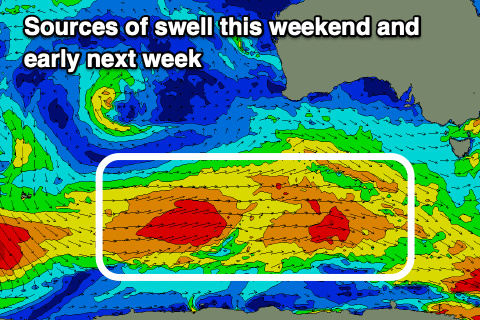
Building levels of mid-period SW swell are due on the weekend, generated by a broad but generally weak polar frontal progression that fired up to the south-southwest of Western Australia mid-week.
This has generated fetches of strong W/SW winds, with a couple of gale-force bursts, with the progression moving under the country today.

Later today but more so tomorrow morning we should see the first pulse of weaker SW swell filling in with sets to 3ft across Middleton 1ft to occasionally 1.5ft on the Mid Coast.
Into the evening but more so Sunday, the strongest pulse of swell energy is due, coming in at 4ft+ across Middleton while the Mid Coast persists around 1ft to occasionally 1.5ft, easing slowly into early next week from 3-4ft and 1ft respectively.
Local winds are tricky thanks to a trough moving in, with light, local offshore breezes due tomorrow, (NW tending W/NW down South and variable on the Mid), with a shallow S/SW change due into the mid-late afternoon.
Sunday now looks dicer for the South Coast with unfavourable, moderate E/NE-E winds due, not too great with the size of the swell. Monday is a little better but also dicey with a light to moderate S/SE-SE'ly due, possibly tending variable for a period during the day.
Tuesday morning looks better as winds go light offshore along with a drop in swell back to 2-3ft across Middleton, tiny on the Mid Coast. The afternoon will be bumpy with sea breezes.

A small background SW groundswell should slow the easing trend Tuesday afternoon, generated by an off-axis fetch of NW gales firing up east of the Heard Island region this evening.
It's due to ease Wednesday from the 2ft range along with fresher N/NE tending N/NW winds ahead of an approaching frontal progression.
The models diverge regarding the make-up and strength of this progression but we could see a low projecting up and under Western Australia, generating a moderate-large sized pulse of W/SW swell later week but with strong winds from the south-western quadrant.
There'll also be some smaller, inconsistent background groundswell in the mix on Thursday, though likely hidden under the close-range energy. More on this Monday. Have a great weekend!


Comments
New triggs cam is great.
Thanks gents.