Great surf today, fun options for the weekend as well
South Australian Surf Forecast by Craig Brokensha (issued Friday July 21st)
Best Days: Today, South Coast tomorrow morning, Mid Coast Sunday and Monday morning, South Coast Monday morning, Tuesday, Wednesday and Thursday South Coast
Features of the Forecast (tl;dr)
- Easing surf Sat with fresh N/NW tending W/NW winds, then stronger W/SW late afternoon (mod-fresh N/NE on the Mid early)
- Moderate sized, reinforcing W/SW swell Sun with strong S winds down South, S/SE on the Mid
- Easing surf Mon with local offshore winds and weak sea breezes
- Mod-large W/SW and SW groundswells Tue with local offshore winds and weak sea breezes
- Easing surf Wed with N winds down South, NE early on the Mid
- Smaller Thu with strengthening N/NW winds
Recap
The swell bottomed out yesterday morning across the state with clean conditions down South but no surf. Tiny and wind affected across the Mid Coast with a kick in swell through the afternoon.
Today is much better on the Mid Coast with cleaner conditions and 2ft to occasionally 3ft sets along with light winds. The South Coast isn't showing any major size with inconsistent and slightly lumpy 3ft off Middleton Bay, bigger down towards Cliffs.
Winds will remain out of the W/NW all day down South while tending moderate N/NW on the Mid Coast.

Plenty of size on the Mid Coast today (Frank)
This weekend and next week (Jul 22 - 28)
The current mix of swells are due to ease back into tomorrow with the Mid Coast easing back to the 2ft range on the favourable parts of the tide, with 3ft sets off Day St, Middleton.
A reinforcing pulse of mid-period W/SW swell is due later in the day but looks to peak Sunday, offering fun 2ft sets across the Mid Coast again. The South Coast should hold 3ft and winds will be tricky.
Early N/NE breezes are due on the Mid Coast tomorrow, tending N/NW into the afternoon ahead of a trough and late W/SW change, while the South Coast should see N/NW tending W/NW winds ahead of the late afternoon W/SW change.
The trough will bring strong, poor S'ly winds to the South Coast Sunday while the Mid should see gusty S/SE winds, favouring protected spots.
Winds are due to be variable Monday morning (weak afternoon sea breezes), creating clean conditions but with easing surf from 1-2ft on the Mid Coast and 2-3ft down South.

Now, later in the day we'll likely see hints of a new long-period W/SW groundswell showing, ahead of a peak on Tuesday.
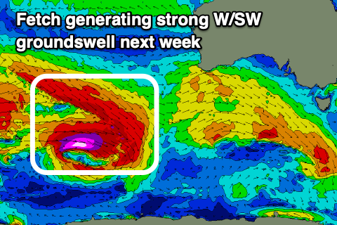
A broad, complex low has formed around the Heard Island region, with a great pre-frontal fetch of severe-gale W/NW winds sitting just above a tight fetch of core, storm-force W'ly winds while tracking slowly east-southeast.
We'll see the fetches and low breaking down while pushing closer to us, south of Western Australia, though the backside of the progression is expected to produce an additional fetch of severe-gale to possibly storm-force W'ly winds south of the country Sunday evening.
What this will result in is a strong, moderate to large W/SW groundswell for Tuesday morning, with a reinforcing SW groundswell pulse for the afternoon.

The Mid Coast looks to come in at an inconsistent 2ft while the South Coast will see strong 6ft sets under local offshore winds ahead of weak sea breezes.
The swell is due to ease slowly into Wednesday with favourable N'ly winds again, smaller Thursday with stronger N/NW winds.
Longer term a strong Southern Ocean frontal progression looks to develop bringing plenty of swell from next weekend onwards, into the following week along with favourable winds. More on this Monday. Have a great weekend!


Comments
Hey guys, a cam at Seaford would be the go.
Great forecast, thanks for these Craig
Trigs cam? Anyhow this year is what we've been missing for years and all you plebs playing down what I've said before when the last 4 years have been av. Finally seems nornal but lacking in major sw swells. I know it's early Craig but what do u see in coming months with the met holding off on el'nino and what ur predictions are?
Regards aaaaaaaaaaaàndy